Walk 2617 - printer friendly version
Nappa Cross & Victoria Cave from Langcliffe Walk
Author - Mike Bexley
Length - 9.5 miles / 15.4 km
Ascent - 1500 feet / 455 metres
Grade - moderate
Start - OS grid reference SD823651
Lat 54.08151 + Long -2.2720389
Postcode BD24 9RD (approx. location only)
It is always interesting to cross over the tops from one valley or dale to another and this Yorkshire Dales walk does just that. Many people set out into this attractive part of the National Park but stop after visiting the caves. This route makes it a longer walk keeping the main caves to the end. Except in very dry weather, good waterproof footwear is advisable on these paths and either a GPS or map and compass is essential.
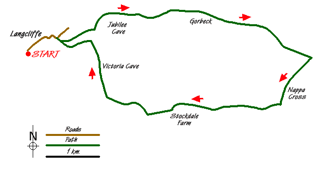
The start is from a small signed car park by the village school in Langcliffe (Grid ref. SD823651), a couple of miles north of Settle. Continue up the very steep narrow road, over the cattle grid, passing Leys Barn. At the point where the road makes a sharp left turn continue straight on up a track to the double gate (Grid ref. SD 830 652).
Immediately after this gate turn left, up the steep bank, to follow the grassy path up to a tall stile over the wall. The other side of the wall is Jubilee Cave, which is not very deep but a good stop to regain your breath and have a drink. You will be passing many caves so I must repeat the local warnings 'that it is dangerous to stand near or enter the caves. There have been many fatal rock falls '.
Continue by taking the left hand track. This descends to follow the left boundary wall to its corner (Grid ref. SD 849 657). From this point navigation can be a problem due to motorbikes tearing up the path and making wet, rutted tracks in other directions. You are heading towards Gorbeck (Grid ref. SD 862 657) and providing you are heading east on some form of track you will see the stiles or gates in the high walls.
After Gorbeck follow the right hand track, walking south-east to a five bar gate in the wall. You will have noticed left and right boundary walls have met at this point. Then keep to the right of the wall to the corner at grid ref. SD 881 649. Once this point has been reached there are no more map reading problems.
The views on your left have been across to Fountains Fell and Pen-y-ghent but now you are looking down on Malham Tarn. Putting this view behind you, climb the gentle hill south to Nappa Cross (Grid ref. SD 874 640). Reaching a path junction bear right along a gentle clear path heading west. This descends past the well-kept Stockdale Sheep Farm down in the valley.
Continuing further down the dale you pass Horseshoe Cave high up on your right. The onward path leads you to reach a wall corner near Attermire Cave (Grid ref. SD 839 641). Turn right here and climb the very steep path with the wall on your left. The path then crosses a field to a wall again on your left. The steep slopes on your right contain the Albert and Victoria Caves, which are not very visible from the path. The only indication is a low safety sign with a narrow steep path climbing to the right. A second path branches left up the scree to grilled Albert Cave, whilst taking the first path will lead you to the larger Victoria Cave.
Continue on the 'valley' path with the wall on your left until you reach the end of the wall and a gate (Grid ref. SD 837 653). Turn left down a lane following the left hand wall. This leads you to the double gate passed at the start and onto the lane for a final descent into Langcliffe.
Messaging & Social Media
Message Walking Britain and follow the latest news.

Mountain Weather
Stay safe on the mountains with detailed weather forecasts - for iOS devices or for Android devices.