Walk 2625 - printer friendly version
Torside Clough from Longdendale Walk
Author - Peter Schofield
Length - 4.5 miles / 7.3 km
Ascent - 1300 feet / 394 metres
Grade - moderate
Start - OS grid reference SK068983
Lat 53.481379 + Long -1.8990023
Postcode SK13 1JF (approx. location only)
Bleaklow has a reputation as a place of featureless boggy wastes and forbidding peat groughs. To some however, this very remoteness makes it a truly magical place, and this short Peak District walk, which can be easily completed in half a day, gives a taster of some of the many delights that Bleaklow has to offer. Moreover being just twelve miles from Manchester City Centre, it makes a great walk for the long summer evenings. Can anyone think of a better way to shake off the cares of a day in the office?
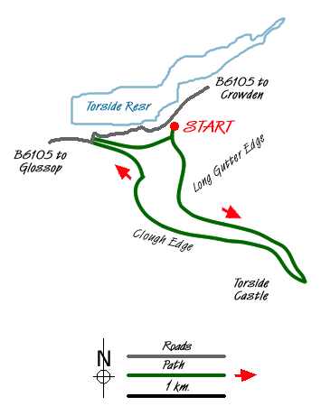
The route starts at Torside car park on the B6105 Crowden to Glossop road (Grid ref. SK068983). Go through the exit in the SE corner, cross the Trans Pennine Trail and follow the path ahead signed to Torside Clough. The path goes uphill bearing right towards a broken wall. Continuing along the wall, it finally crosses it to climb the flank of Long Gutter Edge and up the east side of the boulder strewn Torside Clough.
There are no problems following the path as far as Torside Grain. Torside Castle and the Pennine Way are clearly visible on the opposite bank while behind a splendid panorama opens out across Longdendale towards Laddow Rocks and Lad's Leap. Beyond Torside Grain, while conditions underfoot remain generally good, the path becomes more intermittent. The easiest way ahead is to walk parallel to a sheep fence above you on your left to a stile at the point where the fence drops down steeply to Torside Clough (Grid ref. 079967). The fence is part of a long term project to regenerate the vegetation on Bleaklow and a board at the stile provides more information about the scheme. Beyond the stile, continue upstream for a further 400m to reach the Pennine Way at the ford at John Track Well (Grid ref. 081964).
From here, the route is easy to follow for the remainder of the walk. Cross the stream and follow the Pennine Way along Clough Edge to the B6105 at the former Torside level crossing (Grid ref. 058980). This is a classic edge walk and as the ground falls steeply away to the right, extensive views again open out up the Longdendale Valley and across to Black Hill and Holme Moss. On reaching the road, turn east on to the Trans Pennine Trail from where it is an easy walk of little over a kilometre back to the start, (and a further five minute drive for a well earned pint in the pubs of Glossop!)
Messaging & Social Media
Message Walking Britain and follow the latest news.

Mountain Weather
Stay safe on the mountains with detailed weather forecasts - for iOS devices or for Android devices.