Walk 2633 - printer friendly version
Brown Clee Hill Walk
Author - Jake Robertson
Length - 6.3 miles / 10.2 km
Ascent - 1250 feet / 379 metres
Grade - easy/mod
Start - OS grid reference SO575866
Lat 52.475665 + Long -2.6271444
Postcode SY7 9HZ (approx. location only)
Twin topped Brown Clee Hill is the highest of all the Shropshire hills yet nowhere near as popular the Long Mynd and other hills in this beautiful County. Rising out of glorious pastoral countryside Abdon Burf, its summit, is a magnificent viewpoint gained by an easy ascent through up ancient common lands.
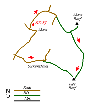
The start and finish is the church (Grid ref. SO575866) in Abdon village where there is very limited roadside parking. From the church walk north up the road to join the Shropshire Way at a t-junction. Go straight on with the Shropshire Way to the phone box at Bank House. A gate on the left leads into a track that makes a steady ascent around Abdon Liberty, emerging onto the plateau top by a wall (Grid ref. SO 592 863) where the Shropshire Way goes right.
To visit the summit of Brown Clee Hill, go straight ahead on a path up through hummocky ground to reach the OS trig point. From the summit at 1772 ft (540 m) there are extensive views over Shropshire and distant views of the Welsh mountains, the Cotswolds and Cannock Chase. (Note - It is necessary to go to the high point in front of the mast to see the full view north.)
Return downhill and turn left on to the Shropshire Way. Stay on this path and follow it south along to the col at The Five Springs (Grid ref. SO 595 854). From here a gentle climb south by the edge of the woods brings you to the 1670 ft (512 m) top of Clee Burf with a good retrospective view back to Abdon Burf.
Just north of the masts a track leads down to a good path descending Clee Liberty to the impressive fort at Nordy Bank and onward down to a minor road at Cockshutford (Grid ref. SO 574 849). Walk along to the crossroads at Lower Cross Lane and turn right for about a mile walk into Abdon. The church is up a lane on the right near the end of the village.
Messaging & Social Media
Message Walking Britain and follow the latest news.

Mountain Weather
Stay safe on the mountains with detailed weather forecasts - for iOS devices or for Android devices.