Walk 2639 - printer friendly version
Cosdon Beacon from South Zeal Walk
Author - Lou Johnson
Length - 6.5 miles / 10.6 km
Ascent - 1200 feet / 364 metres
Grade - easy/mod
Start - OS grid reference SX651934
Lat 50.7245180 + Long -3.9125688
Postcode EX20 2JX (approx. location only)
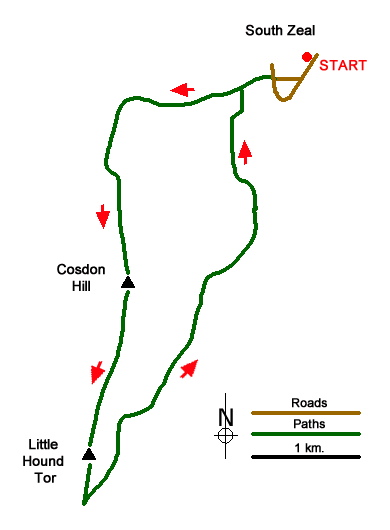
Cosdon Hill or Cosdon Beacon is the most north-easterly of the high Dartmoor hills and as one might expect provides some excellent views. This route is mostly easy to follow although careful navigation in the early stages of the walk through a maze of lanes does require care. It is also worth noting that in poor visibility good map reading and compass skills are necessary.
The start is the car park (grid ref. SX651934) at the southern end of South Zeal village. Exit the car park and turn right along the road. Take the first road on your right and continue to reach a crossroads. Go straight across. You are now on a signed bridleway walking west. Bear left at the first junction and continue ahead to a 'cross-roads' with a footpath on your right (grid ref. SX645931). Ignore the track heading south and continue in westerly direction to reach a T-junction (grid ref. SX643930). Here bear left and continue between walls to reach open country. Passing a number of smaller enclosed fields on your left take the slopes of Cosdon Hill rise to your left. Take the path (one of many on this hill) making a beeline for the summit and the Beacon with its trig point (grid ref. SX636915).
The onward route heads just west of south and you should take the easiest path making for the summit of Little Hound Tor (grid ref. SX632899) passing a shallow col before reaching the highest point. Descend south to a junction of bridleways (grid ref. SX632896) and an adjacent stone circle. Here turn sharp left and follow the clear bridleway as it heads northeast across the moor. The route passes through a walled section with small enclosures to your left before crossing a short area of open moorland. The way ahead then passes between walls again. At a junction (grid ref. SX645929) bear right to reach the crossroads at grid ref. SX645931 encountered on the outward route. Turn right here and follow the outward route back to the car.
For the return, retrace your tracks back down the river bed, turn right at the cross-roads, and then continue on this track (past where you originally met it) until eventually joining back to the way marked footpath. At a cross-roads (Grid ref SJ 237 476) bear left and you should recognise the path that led to the stile at the beginning of the walk. Follow the original path back to the car park.
Messaging & Social Media
Message Walking Britain and follow the latest news.

Mountain Weather
Stay safe on the mountains with detailed weather forecasts - for iOS devices or for Android devices.