Walk 2668 - printer friendly version
Cadair Idris, Craig Cau and Cyfrwy by the Pony Path Walk
Author - Peter Smyly
Length - 5.3 miles / 8.5 km
Ascent - 3000 feet / 909 metres
Grade - mod/hard
Start - OS grid reference SH697152
Lat 52.718715 + Long -3.930542
Postcode LL40 1TN (approx. location only)
According to W A Poucher's book "Welsh Peaks", Cadair Idris is the second most popular mountain in Wales after Snowdon, the highest, even though it is listed in his book as being the seventeenth highest in Wales. Despite it's undoubted merits, it is hard to see really how Cadair Idris could "upstage" a mountain like Tryfan or either of the Glyders. It is, of course, a subjective matter.
Even though Cadair Idris does not hit the "magic" 3,000 foot mark, this fact does not in any way lessen the quality of the views from its ridge. Especially striking are the views looking down on Llyn Cau on one side of the ridge, a crater type of lake in appearance and Llyn y Gadair on the other side with the pink screes and rock of the nearby subsidiary summit of Cyfrwy leading the eye down to the tarn. More distant views include the Mawddach Estuary, the beach at Barmouth and the Cregennen Lakes.
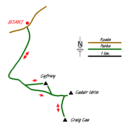
The start of this Snowdonia (Eryri) walk is at the car park at Ty Nant. Walk along the tarmac road to the right to pick up a footpath on the left which leads to the Pony Path. The crags and cliffs of Cyfrwy and Cadair Idris appear ahead. The path gains height to pass through a gate in a wall and here the route divides. One option is to take a narrow path on the left which leads to Llyn y Gadair and the very steep Foxes Path. However, this route opts for the easier alternative of the Pony Path to the col between Cadair Idris and Craig-las.
A clear, rocky path now leads up the ridge to the left with Cadair Idris peeping over the horizon ahead before the col between Cyfrwy and Cadair Idris is reached. At this point there is a plunging view down to the pretty mountain lake of Llyn y Gadair below on the left as the path passes close to the rim of the corrie. The water of the tarn is so clear you can see the bottom in places near to the shoreline even from the ridge above. The Foxes Path on the opposite side of the tarn looks particularly steep and uninviting from here. Llyn Cau cannot be seen from the summit of Cadair Idris though the crater-like cwm that contains it can be seen. Especially in good weather, you can expect plenty of other walkers to be at the top of Cadair Idris which is marked by a triangulation pillar. Near the top there is a large man-made shelter complete with a roof which could easily accommodate a large group seeking shelter from adverse weather.
From the summit of Cadair Idris, rather than repeat the outgoing route in its entirety, descend to the dip between it and Craig Cau, then follow the fellside to the top of the latter to meet up with the Minfford Path. Although this is not a main summit, it is worth the effort of climbing it for the dramatic view looking down on to Llyn Cau way below, especially when seen framed between rocky clefts. Another variation in the return route is to head for the top of Cyfrwy. This summit similarly offers a picturesque view looking down on another mountain lake, Llyn y Gadair with the screes of the Foxes Path as a backdrop. A descent of the Foxes Path is not recommended due to its steepness and loose rock, therefore a safer descent, is to return via the Pony Path, a much safer descent route.
Messaging & Social Media
Message Walking Britain and follow the latest news.

Mountain Weather
Stay safe on the mountains with detailed weather forecasts - for iOS devices or for Android devices.