Walk 2671 - printer friendly version
Hotbank Crags & Housesteads from Vindolanda Walk
Author - Lou Johnson
Length - 5.3 miles / 8.6 km
Ascent - 900 feet / 273 metres
Grade - easy
Start - OS grid reference NY773664
Lat 54.9916630 + Long -2.3563112
Postcode NE47 7JN (approx. location only)
The remains of the Roman Forts at Vindolanda and Housesteads provide an historic focus for this walk. The inclusion of a dramatic section of Hadrian's Wall adds further interest to the route. You are advised to allow plenty of time, as the Roman antiquities are full of interest and far better preserved than expected.
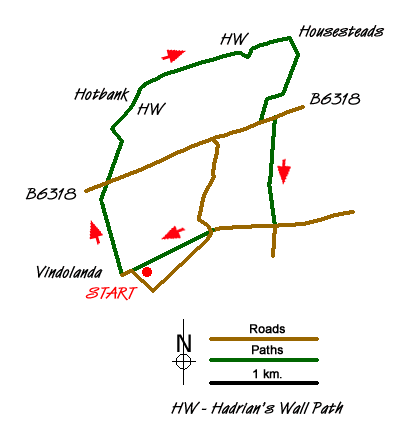
The start is the small car park (grid ref. NY773664) which is located on the south side of the B6318 and accessed via a quiet country lane. This car park is convenient for visiting Vindolanda either before you start the walk or after completion of the route. You can also complete the walk by using the Hadrian's Wall bus service AD122 which runs from April through to September.
After parking exit the car park and turn right along the lane towards Vindolanda. The lane turns sharp left and crosses Bradley Burn. Immediately after take the footpath on your left. This leads past High Shields Farm on your left to exit onto the B6318 (grid ref. NY770674). Turn right along the B6318 and then turn left on to the metalled track where it meets the B6318 at a gate. It is only about 100 yards or so away and follows the line of a wall and is very clear to see. Turn left along this track and continue north to reach Hadrian's Wall. Turn right along the Wall following the Pennine Way and the Hadrian's Wall Path east. On your left is Crag Lough which nestles below Highshield Crags.
Follow the path along the Wall over Hotbank Crags and continue past the point where the Pennine Way heads north to reach Housesteads and the Roman Fort. The remains of the fort are impressive and well worth a visit. Exit the site of the Roman fort to the south and bear left onto a track heading south-west to Deafley Rigg and the B6318 (grid ref. NY785680). Turn left along the road and take the signed bridleway on the right. This leads past East Crinkledykes (on your right) to reach a lane (grid ref. NY786669).
Turn right along the lane and follow it west to the first road junction. Go straight ahead here picking up the path that follows Stangate (the route of an old Roman Road). This leads you back to the lane used at the start. Turn left along the lane and the car park is on your left.
Messaging & Social Media
Message Walking Britain and follow the latest news.

Mountain Weather
Stay safe on the mountains with detailed weather forecasts - for iOS devices or for Android devices.