Walk 2677 - printer friendly version
Circuit of Doddington Moor Walk
Author - Lou Johnson
Length - 3.8 miles / 6.2 km
Ascent - 400 feet / 121 metres
Grade - easy
Start - OS grid reference NT999324
Lat 55.5852440 + Long -2.0031459
Postcode NE71 6AN (approx. location only)
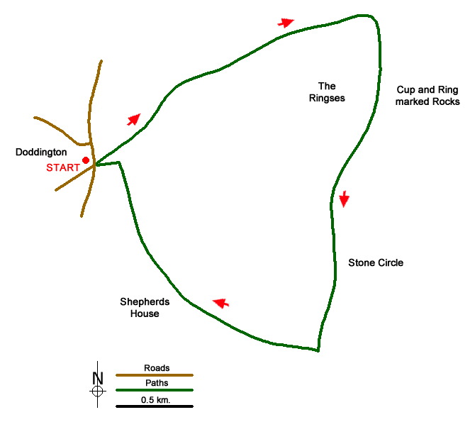
Doddington Moor offers an insight into Britain's Neolithic past with a well preserved stone circle complete with king stone and many cup and ring marking on stones scattered across the area. An Ordnance Survey 1:25000 Explorer map is useful if you want to undertake a more detailed investigation of the various locations as they are all marked on the map.
Limited parking is available in Doddington and there is a space on the B6526 at grid ref. NT999324. After parking walk up the lane past the entrance to the golf club. After approximately one kilometre turn right off the track (grid ref. NU016334). The path is signed to Weetwoodhill. After 600 metres you reach a junction of fences and paths (grid ref. NU015327). Continue ahead passing Kitty's plantation on your left to reach the stone circle (grid ref. NU013306).
Continue ahead to reach a gate (grid ref. NU012313). Do not pass through the gate, instead turn right and keeping the fence line on your immediate left continue to pass in front of Shepherd's House (grid ref. NU004316). Do not descend on the path going right and continue along the escarpment edge heading north-west. Stay on the path as it descends across the moor and continue into Doddington.
Messaging & Social Media
Message Walking Britain and follow the latest news.

Mountain Weather
Stay safe on the mountains with detailed weather forecasts - for iOS devices or for Android devices.