Walk 2720 - printer friendly version
Pendle Hill (use in mist) Walk
Author - Andy Chaplin
Length - 5.0 miles / 8.1 km
Ascent - 1090 feet / 330 metres
Grade - moderate
Start - OS grid reference SD823403
Lat 53.8586180 + Long -2.2705898
Postcode BB12 9JT (approx. location only)
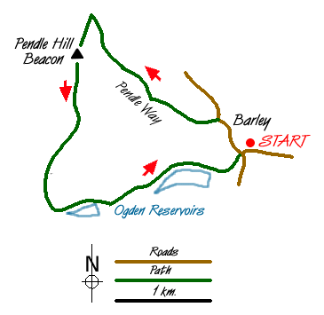
Pendle Hill rises from the surrounding countryside in a dramatic fashion. The hill is famous for its connection with the "Witches of Pendle" and the outward section of this walk follows the Pendle Way, which is identified on way marks by a witch on her broomstick. This route is graded medium despite being designed for use in misty weather as careful navigation is still required. A longer version of this walk is detailed in walk 1287.
The start is the car park at Barley Green (grid ref. SD823403) where there is an information centre, cafe and toilets. From the car park take the lane heading north into the village of Barley turning left onto the signed "Pendle Way" (Grid ref. 821405) after approximately 300 metres. This well marked path climbs steadily to Ing Ends and onto Brown House. Ahead can be seen the steep slope that leads to the summit plateau of Pendle Hill.
After Brown House the path crosses fields to reach Pendle House after which the path steepens to climb diagonally across the slope. The path is paved in sections and despite the angle you will soon have completed most of the ascent and reached a wall. Do not cross the wall but turn round and head across the relatively flat summit area to the trig point located about 400 metres to the south.
On a misty day it is easier to stay on the Pendle Way which means carrying straight on past the trig point then, after 275m, bear right at a point where 2 paths diverge. The route is marked by a series of stone mounds and starts to descend from the top of the hill until it is apparent that you are walking along the right side of Boar Clough. At the point where Ogden Clough comes down from your right, cross the Boar clough stream and take the path down and to the left towards the top of the Upper Ogden Reservoir.Take the clear track east to pass alongside Lower Ogden Reservoir. This lane leads without any problems to bring you back to the start.
Messaging & Social Media
Message Walking Britain and follow the latest news.

Mountain Weather
Stay safe on the mountains with detailed weather forecasts - for iOS devices or for Android devices.