Pendle Hill (use in mist) from Barley Green
Forest of Bowland Walk
Region - Forest of Bowland
County/Area - Lancashire
Author - Andy Chaplin
Length - 5.0 miles / 8.1 km Ascent - 1090 feet / 330 metres
Time - 3 hours 40 minutes Grade - moderate
Walk Route Description
Click image to see photo description.
Pendle Hill rises from the surrounding countryside in a dramatic fashion. The hill is famous for its connection with the "Witches of Pendle" and the outward section of this walk follows the Pendle Way, which is identified on way marks by a witch on her broomstick. This route is graded medium despite being designed for use in misty weather as careful navigation is still required. A longer version of this walk is detailed in walk 1287.
The start is the car park at Barley Green (grid ref. SD823403) where there is an information centre, cafe and toilets. From the car park take the lane heading north into the village of Barley turning left onto the signed "Pendle Way" (Grid ref. 821405) after approximately 300 metres. This well marked path climbs steadily to Ing Ends and onto Brown House. Ahead can be seen the steep slope that leads to the summit plateau of Pendle Hill.
After Brown House the path crosses fields to reach Pendle House after which the path steepens to climb diagonally across the slope. The path is paved in sections and despite the angle you will soon have completed most of the ascent and reached a wall. Do not cross the wall but turn round and head across the relatively flat summit area to the trig point located about 400 metres to the south.
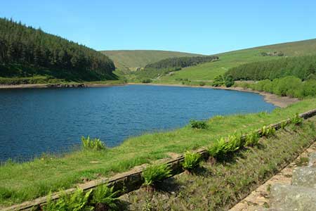
On a misty day it is easier to stay on the Pendle Way which means carrying straight on past the trig point then, after 275m, bear right at a point where 2 paths diverge. The route is marked by a series of stone mounds and starts to descend from the top of the hill until it is apparent that you are walking along the right side of Boar Clough. At the point where Ogden Clough comes down from your right, cross the Boar clough stream and take the path down and to the left towards the top of the Upper Ogden Reservoir.Take the clear track east to pass alongside Lower Ogden Reservoir. This lane leads without any problems to bring you back to the start.
Maps 

| Ordnance Survey Explorer OL41 | Sheet Map | 1:25k | BUY |
| Anquet OS Explorer OL41 | Digital Map | 1:25k | BUY |
| Ordnance Survey Digital Map Subscription | |||
| Latest Ordnance Survey Discounts | |||
Other walks nearby
| Walk 3111 | Barley Circular | easy/mod | 7.5 miles |
| Walk 1818 | Downham & Pendle Hill | moderate | 8.0 miles |
| Walk 1655 | Downham & Pendle Hill (short version) | moderate | 6.3 miles |
| Walk 2938 | Nick of Pendle from Pendleton | easy/mod | 6.3 miles |
| Walk 2632 | The Ribble Valley from Sawley | easy/mod | 9.0 miles |
| Walk 2293 | Weets Hill | easy/mod | 5.3 miles |
| Walk 2217 | Clitheroe Town Trail - Ribble Valley | easy | 1.0 miles |
| Walk 2196 | Clowbridge Reservoir & Singing Ringing Tree | easy/mod | 4.0 miles |
| Walk 2304 | East Marton and the Drumlins | easy/mod | 5.5 miles |
| Walk 2861 | Pinhaw Beacon from Lothersdale | easy | 4.0 miles |
Recommended Books & eBooks
Walking on the West Pennine Moors
 This guidebook describes 30 walks on the West Pennine Moors, around Blackburn, Darwen, Chorley and Bolton, home to some of the most inspiring and exhilarating walking country. The walks range from short, easy rambles to more challenging hikes covering a variety of terrain, all of it easily accessible for day walking.
More information
Walking in the Forest of Bowland and Pendle
 A guidebook to 40 diverse circular day walks suitable for walkers with navigational skills. The Forest of Bowland and Pendle are two of north west England's upland AONBs, perfect for walkers who enjoy exploring rough hilly, sometimes pathless terrain. The routes include Ward's Stone, Pendle Hill, Longridge Fell and Fair Snape Fell.
More information
