Bath to Keynsham over Kelston Round Hill
Cotswolds Walk
Region - Cotswolds
County/Area - Somerset & Gloucestershire
Author - Peter Schofield
Length - 9.0 miles / 14.6 km Ascent - 950 feet / 288 metres
Time - 5 hours 30 minutes Grade - easy/mod
Maps 

| Ordnance Survey Explorer 155 | Sheet Map | 1:25k | BUY |
| Anquet OS Explorer 155 | Digital Map | 1:25k | BUY |
| Ordnance Survey Landranger 172 | Sheet Map | 1:50k | BUY |
| Anquet OS Landranger 172 | Digital Map | 1:50k | BUY |
Walk Route Description
Click image to see photo description.
This linear walk explores some of the country on the southern fringe of the Cotswolds between Bath & Bristol which has remained remarkably unspoilt given the proximity of those two cities. The availability of good public transport makes this walk accessible without the need of a car.
The first section follows the Cotswold Way as it leaves Bath. As there are no relevant way markers in the City Centre, I've described the urban section in some detail. From the starting point at the west door of Bath Abbey (grid ref. ST751648), go ahead and turn right into Stall St. Continue for 200m turning left into Quiet St and walk for 100m to the SE corner of Queen Square. Turn right up the hill out of the square to arrive after 200m at one of Bath's architectural gems, The Circus with its elegant Georgian terraces adorned with mysterious astrological symbols.
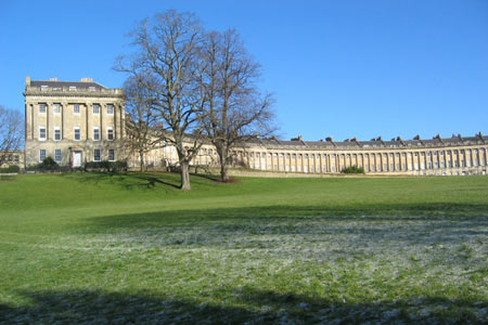
Go left into Brock St and after a further 150m you arrive at what is arguably the city's most recognised location, the Royal Crescent. Bear left diagonally across the green and descend towards the lower end of Marlborough Buildings ahead. Cross the road and continue up the lane below the terrace to turn right at another road. Follow this as it gently rises for 150m to reach Weston Rd.
The first Cotswold Way marker we've encountered can be seen on the opposite side of the road. Cross over and follow the path up the hill over a golf course to reach Sion Hill. Turn left and continue on Sion Hill as it climbs to a T-junction, where another CW way marker shows the way. From this point onwards the CW is well waymarked and route finding presents no problem.
The outlook now becomes more rural and after another short urban section at Weston, the city is finally left behind and the walk enters open countryside. As the route climbs gently, Kelston Round Hill with its distinctive clump of trees appears ahead. Across the valley the neo-classical Beckford's Tower is prominent while behind views open out over the city below.
Temporarily leave the Cotswold Way at grid ref. R ST711674 and follow the concessionary path up to the summit of Kelston Round Hill. Should visibility be good, your reward is a magnificent vista stretching from Bath to Bristol and beyond to South Wales. To rejoin the CW go through the clump of trees and descend to meet it at grid ref. ST712675 . Go left and follow the clearly signed route as it climbs to Prospect Stile, another fine viewpoint with an information board identifying the main sights. Continue past the west end of Bath racecourse and follow the waymarked route to a path junction (grid ref. GR ST707689).
At this point, the Cotswold Way turns right while our route descends ahead across a field towards the village of North Stoke. The path is not always easy to find but aim for the squat church tower below to arrive at a lane and follow it as it goes around the bottom side of the church to enter the village. North Stoke is an unspoilt village with typical Cotswold architecture and parts of the church date from the 12thC. Continue down the village street for 150m and go right on to a byway to arrive at a path junction (grid ref. ST701692). Cross over a stile past a "Private Land" sign and follow the clear path across the fields towards the village of Upton Cheyney arriving at a lane which climbs to the village.
Turn left and follow the road as it swings left through this attractive spot. Just before the pub go right down a path in front of the imposing Upton House. The path is way marked as the Monarch's Way and will be our route for the remainder of the walk. Again it's well signed and navigation is easy. Continue over the fields to Bitton which (unlike the previous villages) has become a commuter suburb with modern housing. Cross over the A431 down the lane opposite towards St Mary's parish church, parts of which date back to 1086. A number of old houses cluster around the church to give an indication of what the village must have looked like in days gone by.
Leaving the churchyard go right and then left following the frequent Monarch's Way markers. The occasionally muddy path continues across fields under the preserved Avon Valley Railway to finally arrive at a marina on the River Avon. Follow the riverside path to the A4175 at the Lock Keepers Inn. Go left on to the road as it crosses the Avon to reach Keynsham railway station after 400m and the bus stops at the parish church after a further 100m.
Both the start at Bath and the end at Keynsham benefit from frequent train and bus services between Bath and Bristol.
Other walks nearby
| Walk 2087 | The Cam Brook Valley from Southstoke | easy | 5.5 miles |
| Walk 1891 | Solsbury Hill from Northend | easy | 3.0 miles |
| Walk 1567 | Keynsham to Bath on the south side of the Avon | easy/mod | 11.1 miles |
| Walk 3278 | Hinton & Dryham Circular | easy | 3.0 miles |
| Walk 3675 | Bedlam and Great Elm from Mells | easy/mod | 4.7 miles |
| Walk 3347 | Ford & North Wraxall from Castle Combe | easy/mod | 8.0 miles |
| Walk 2699 | Lacock - a village stroll | easy | 1.0 miles |
| Walk 2212 | Bristol Curiosities Trail | easy | 1.5 miles |
| Walk 2213 | Bristol Maritime Trail | easy | 1.5 miles |
| Walk 2214 | Bristol Literary Trail | easy | 1.5 miles |
Recommended Books & eBooks
The Cotswold Way
 Guidebook to walking the Cotswold Way National Trail. Between Chipping Campden and Bath, the 102 mile route explores the Cotswolds AONB. Described in both directions over 13 stages, the Cotswold Way can be walked year round and is suitable for beginner trekkers. Includes separate OS 1:25,000 map booklet of the route.
More information
The Cotswold Way Map Booklet
 Map of the 102 mile (163km) Cotswold Way National Trail, between Chipping Camden and Bath. This booklet is included with the Cicerone guidebook to the trail, and shows the full route on OS 1:25,000 maps. The trail typically takes two weeks to walk, and is suitable for walkers at all levels of experience.
More information
Messaging & Social Media
Message Walking Britain and follow the latest news.

Mountain Weather
Stay safe on the mountains with detailed weather forecasts - for iOS devices or for Android devices.