Walk 2806 - printer friendly version
Udal & Aird a' Mhorain Point from Greinetobht Walk
Author - Andy Smith
Length - 6.5 miles / 10.6 km
Ascent - 150 feet / 45 metres
Grade - easy/mod
Start - OS grid reference NF820754
Lat 57.655788 + Long -7.3336365
Postcode HS6 5BP (approx. location only)
This truly stunning part of North Uist lies in the northern most section of the island and offers truly outstanding views in a short space of time. It is best enjoyed on a fine day when the tide is out or receding as the sands here are vast. A worthwhile buy would be a tide book which can be purchased from Lochmaddy or a number of shops on Benbecula Island.
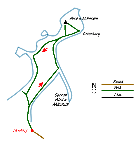
To reach the start head along the north coast road to the tiny settlement of Greinetobht. Turn off into the village and continue along the road to the coast where a tiny car park can be found at grid reference NF820754. Leave the car park and head north along the obvious sand track with the dunes to your left. Shortly the track finishes. Continue your walk along the beach where at low tide the sands are so big you will not see the sea at all. Warning: Whilst this walk is best enjoyed at low tide it is important not to walk too far out from the dunes although it easy to be tempted. There are ferocious tides here up to 6m high that race across the sands. Remember despite the picturesque beach it can be a deathtrap.
Continue along the beach for about an hour towards the Corran Aird a' Mhorain sand spit in the dunes, which should now be in view. Once reached, cross the sandy section at its lowest point and turn left along another stunning beach. After 15 minutes the beach starts to turn northeast, leave it here and climb through the dunes where a farm track should be within 25 metres. Turn right along the track and follow.
The going ahead is now absolutely stunning as you follow this pure white track north with views to your right of Berneray across the turquoise blue sea. At grid reference NF828785 the path meets another faint track, try and stay left here although they both have the desired effect. Shortly a trig point will be seen to your left, although tempted at this stage, stay on route towards the ancient cemetery following a yellow post marking the path.
Follow the path around the cliff edge, stay alert as the views tempt you to look out to sea! The cemetery is finally reached with the ancient well in view. Some of the graves here are fairly recent, within 50 years or so but there is no sign of any church remaining. This is a very moving place to be and a good place to take a short break and pay your respects.
Leave the cemetery to the northwest climbing up an open field where you will cross back over the track that brought you in. Continue though the high dunes where the trig point can be found very easy, although not in direct view. This point is wonderful as you can look down on the whole spit across the dunes and realise what a well balanced environment these islands are. Triigh Lar beach is one of the finest on the Uist's and looks huge from here. To the North the Small Isle of Boreray can be seen, the west produces fine views of the Hiesker Islands and St Kilda can clearly be seen, 53 miles offshore as a distinct "v" shape coming out of the sea.
Once you have filled the memory the memory card on your camera, leave the trig point and head down the dunes towards the farm track once again. After a few minutes the path splits again, make sure to stay right here leaving the main one. Shortly the path turns sharply left at grid reference NF820779. Continue here along the Machair dunes, and although not shown on OS maps there is a superb track here.
A totally essential part of this trip is to briefly leave your route and make the short climb over the dunes to Triigh Lar beach, although you will hear it and want to anyway! Nothing can prepare you for the shock once you pop over the dunes - this beach is immense and what a view you have from here. If you are lucky you may see a few people from here but expect to enjoy the view alone. The sands are stunning and unbroken. However so take care of the drop to the beach as it is around 25 metres!
Rejoin the track and continue along until a small farm building is reached (grid ref. NF806762). Turn left here and join up with the beach on the other side where you came in. Turn right along the beach back to the car which can be seen a long way off. Another truly stunning day on the Outer Hebrides is achieved with minimal effort.
Messaging & Social Media
Message Walking Britain and follow the latest news.

Mountain Weather
Stay safe on the mountains with detailed weather forecasts - for iOS devices or for Android devices.