Walk 2826 - printer friendly version
Winscar Reservoir Circular Walk
Author - Andy Chaplin
Length - 8.9 miles / 14.5 km
Ascent - 1000 feet / 303 metres
Grade - moderate
Start - OS grid reference SE157024
Lat 53.5180430 + Long -1.7646896
Postcode S36 4TF (approx. location only)
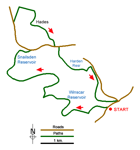
The car-park side of Winscar reservoir can be very busy but as you head up on open country towards Snailsden it is usually very quiet. On this Peak District walk there are three reservoirs to see, sections of the Kirklees Way and Holme Valley Circular Walk to follow and on the way you pass Elysium as well as Hades - so how come places in West Yorkshire ended up with names like that?
There are three places to park near Winscar reservoir - (1) at SE155030 off the Dunford Road would make this walk the shortest, (2) at SE152020 is closest to the start of the open-country walking or (3) at SE157024 has the largest parking area and is where this description starts.
Leave the Trans Pennine car park (3), cross the main road and walk up Don View road. Keep straight on up the gated road between the gardens on your left and the river Don on the right and after the second gate there is a path that leads up on the left to the top of the reservoir dam wall. Go west towards the sailing club where you meet the road from car park (2) and you will see the gate to the open country just in outside the sailing club entrance.
Follow the path/sheep track around the sailing club fence until going slightly inland to cross the first inlet before the end of the club compound - there are stone "fords" across the streams. Stay on the moors side of the wire fence until you come to a gate before reaching Dearden Clough. Stay close to the water's edge to cross the clough then climb up towards the trees that are the Dearden Foot plantation - again staying on the moors side of the fencing.
This is the end of the open country/sheep path walking because, from the north west of the plantation, there is a moors/shooting track that leads up to an even better maintained moors track at SE141028. Take the right hand fork here and follow the track to the farm near Wetshaw Edge. As you approach it there are signs warning you to keep out, so go around the north of the farm buildings and pick up the track heading north.
After passing through a gap in the next wall follow the track to the left then pick up the path/track that is indicated by wooden posts and leads in a loop around Snailsden Edge. The trig point is just to the north of the track. After approaching Holme Moss transmitter for some time the path then turns north and east then descends towards Snailsden reservoir.
From the reservoir follow the track north and eastwards to the road then go west on Linshaws Road. After just over half a mile go right on the track that is marked as the Kirklees Way and follow it as it goes right again past the farm named Elysium. Shortly before the woods start there is a path off on the right (not marked as such but) which is the Holme Valley Circular Walk. Follow this past the ruined farm at Hades (look out for the stone writing) and carry on back up to Linshaws Road.
Go a little left, cross over and follow the track down to Harden Clough so that you then come along the south of the reservoir. Cross over the Harden reservoir dam wall in order to get onto the Dunford Road which heads back to Winscar Reservoir. After a quarter of a mile a road off on the left leads down to a car park (1) and then the road leads on to the gated road over the reservoir dam wall.
My choice for getting down to the lower Dunford car park (3) was to walk east from the start of the dam wall across Broad Hill Bank, which gives good views down the Don valley, then come back on Brook Hill Lane.
Messaging & Social Media
Message Walking Britain and follow the latest news.

Mountain Weather
Stay safe on the mountains with detailed weather forecasts - for iOS devices or for Android devices.