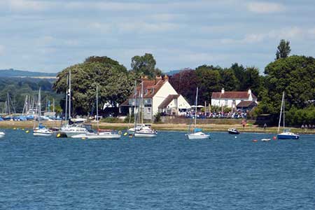
Dell Quay from Chichester Marina
Chichester Harbour Walk
Region - Chichester Harbour
County/Area - West Sussex
Author - Lou Johnson
Length - 3.8 miles / 6.2 km Ascent - 50 feet / 15 metres
Time - 2 hours 0 minutes Grade - easy
Maps 

| Ordnance Survey Explorer OL8 | Sheet Map | 1:25k | BUY |
| Anquet OS Explorer OL8 | Digital Map | 1:25k | BUY |
Walk Route Description
Click image to see photo description.
A short West Sussex walk that is ideal for combing with a leisurely lunch at Dell Quay. Depending on tides you will have varying views from mudflats to high water. The start is the car park (grid ref. SU835010) which is reached off the A286 south of Stocksbridge and signed Chichester Marina.
After parking walk along the south side of the Marina with the many craft to your right. Cross the lock gates and continue north along the footpath running parallel to the shores of the Chichester Channel for just over a mile to Dell Quay.
Turn right along Dell Quay Road, which leads back to the A286. After 500 metres take the footpath (track) on your right (grid ref. SU840027). This leads you past New Barn Farm on your left and continues back to the western end of Chichester Marina. Here turn left, and with the boats to your right, complete the circuit of the Marina and return to the car park.
Other walks nearby
| Walk 2044 | Six Harbour Villages, Chichester | moderate | 10.0 miles |
| Walk 2368 | Bosham & Fishbourne | easy | 5.2 miles |
| Walk 2177 | West Wittering to Chichester (New Lipchis Way) | easy/mod | 9.2 miles |
| Walk 1656 | Thorney Island circular from Prinsted | easy/mod | 9.0 miles |
| Walk 2043 | Thorney Island from Emsworth | easy/mod | 9.0 miles |
| Walk 3548 | Stoughton, Kingley Vale & Bow Hill from Stoughton Down | easy/mod | 5.2 miles |
| Walk 1872 | Charlton, Singleton & Goodwood Circular | easy/mod | 6.5 miles |
| Walk 1835 | Treyford & Didling from Hooksway | easy/mod | 6.0 miles |
| Walk 2487 | Littlehampton to Climping | easy | 5.0 miles |
| Walk 3080 | Arundel Park and the River Arun | easy/mod | 7.2 miles |
Recommended Books & eBooks
No suggestions for this area.Messaging & Social Media
Message Walking Britain and follow the latest news.

Mountain Weather
Stay safe on the mountains with detailed weather forecasts - for iOS devices or for Android devices.