Cromford Canal & Black Rocks from High Peak Junction
Derbyshire Walk
County/Area - Derbyshire - South East Derbyshire
Author - Angela Clarke
Length - 6.8 miles / 11 km Ascent - 1300 feet / 394 metres
Time - 4 hours 40 minutes Grade - easy/mod
Maps 

| Ordnance Survey Explorer OL24 | Sheet Map | 1:25k | BUY |
| Anquet OS Explorer OL24 | Digital Map | 1:25k | BUY |
Walk Route Description
Click image to visit gallery of 6 images.
A walk that explores parts of Derbyshire's Industrial Heritage whilst also giving stunning and wide-ranging views that include Crich Stand, Carsington Reservoir and the Derwent Valley. Generally good paths which can be muddy in places. One very short, stepped, steep section. It is worth noting that if you reversed the route there would be a long and steep climb at the start to the top of Sheep Pasture Incline.
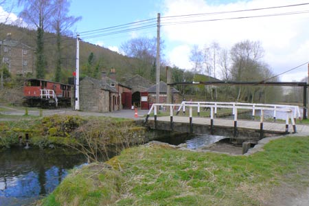
From the back of the car park (grid ref. SK 3148 5609) turn right over the bridge, cross the River Derwent to reach Cromford Canal and High Peak Junction. At High Peak Junction it is still possible to visit the old workshops where the chains and haulage equipment used on the old High Peak Railway were maintained.
Turn left to walk along the canal past, the steam operated, Leawood Pumphouse. Shortly after, at an old canal lock gate, cross the canal and continue along the opposite side of the canal. This stretch of the Cromford Canal is now a nature reserve, which in recent years has seen the return of Water Voles to its banks.
Just before Leawood Tunnel leave the canal path taking the footpath on the right, signed for Homesford Cottage. Cross the bridge over the Derwent, go under the tunnel and follow the track to the A6. Cross the A6 and follow the track opposite behind the houses. As you approach a metal gate take the track which heads uphill but look for a gap in the fence, almost immediately on your right, to follow a clear footpath uphill through Birch Wood. As you walk along the top of the wood you will reach a tarmac track, continue straight ahead along this to re-enter the wood by the entrance to Birch Wood campsite.
At the end of the campsite's first field take the footpath into its second field and follow the path to the barn opposite. It is from this point that the views open up to extend from Crich Stand to Alport Height. Cross a track, the Midshires Way, to follow the signed footpath straight ahead across four fields. In the fourth field don't take the stone stile, directly opposite, out of the field, instead take the footpath, through the gap, on the right of the field.
Continue straight ahead across three fields to emerge at a track lined with gorse bushes, follow this to a farm track. Continuing straight ahead, follow the track past the farm to the road. Turn right downhill towards Bolehill.
Just before the first house in Bolehill take the footpath, on the right, uphill. When the steps end continue, straight ahead, uphill. As the ascent eases look out for the stile into the wood on your left. Continue along the path, uphill, through the wood to emerge, via a gate, at Bolehill's summit trig point. From here Carsington Reservoir and Middleton Moor come into view.
From the summit take the path on the left heading downhill next to the fence. Ignore the first gate in the fence but take the second gate through the fence to follow the stepped path down to a post with green and blue circles.
Bear left, then right, to a track leading downhill to Black Rocks. If you wish to explore Black Rocks there is clear path at the back of the rocks that takes you onto the top of the rocks. Although this involves a bit of scrambling and it is exposed on the top of the rocks the views across the Derwent Valley are stunning.
After passing Black Rocks turn right onto the High Peak Trail, which follows the route of the old High Peak railway line. Follow the trail back to High Peak Junction first passing the old Engine House at the top of Sheep Pasture Incline and then the 'Catch Pit' at the foot of the incline. Cross the canal and return to the car park via the bridge over the River Derwent.
Other walks nearby
| Walk 2627 | Cromford to Bakewell | moderate | 11.5 miles |
| Walk 2218 | Cocking Tor from near Matlock | moderate | 9.5 miles |
| Walk 2993 | Carsington, Brassington & Cromford and High Peak Railway from Middleton | moderate | 9.5 miles |
| Walk 2701 | Harboro Rocks & Brassington | easy/mod | 6.5 miles |
| Walk 3672 | Carsington Water, Hognaston & Madge Hill | easy/mod | 5.5 miles |
| Walk 1378 | Carsington Circular | easy | 4.5 miles |
| Walk 1379 | Carsington and Harboro Rocks | easy/mod | 5.8 miles |
| Walk 2559 | Stanton Moor & The Nine Ladies Stones from Winster | moderate | 9.0 miles |
| Walk 3196 | Stanton Moor and Robin Hood's Stride from Winster | easy/mod | 7.0 miles |
| Walk 2136 | Wensley & Brightgate | easy/mod | 6.2 miles |
Recommended Books & eBooks
Walking in Derbyshire
 Walking guidebook to 60 circular day walks in Derbyshire and the Peak District. Includes the Derwent, Wye and Trent river valleys, near Derby, Matlock, Glossop, Bakewell and Ripley. Routes range from easy to moderate and are between 4 and 14km (2 to 10 miles). Walks focus on places of interest, from Stone Age forts to castles to grand estates.
More information
Walking in the Peak District - White Peak East
 Guidebook describing 42 half-day and day walks in the limestone landscapes of Derbyshire's White Peak, part of the Peak District National Park. One of two volumes, this book covers the east of the region, with potential bases including Bakewell, Eyam, Castleton, Birchover, Matlock and Wirksworth.
More information
Messaging & Social Media
Message Walking Britain and follow the latest news.

Mountain Weather
Stay safe on the mountains with detailed weather forecasts - for iOS devices or for Android devices.