Walk 2938 - printer friendly version
Nick of Pendle from Pendleton Walk
Author - Lou Johnson
Length - 6.3 miles / 10.2 km
Ascent - 920 feet / 279 metres
Grade - easy/mod
Start - OS grid reference SD755396
Lat 53.8520490 + Long -2.3739169
Postcode BB7 1PX (approx. location only)
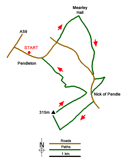
This Forest of Bowland walk starts from the attractive village of Pendleton with Pendleton Brook running through the main street. The route leaves the village and climbs on to the ridge of hills and moorland lying to the southeast of the village from where there are wide views across the surrounding countryside. The walk continues across Pendleton Moor to the Nick of Pendle where the road south from Clitheroe crosses the ridge. From here a brief exploration of The Rough with a visit to the OS trig point completes the route.
The start is the village car park behind the Swan with Two Necks pub (grid ref. SD755396). Exit the car park and turn left and follow the stream uphill ignoring side streets and tracks off to the right. Continue past the Church (on your right) and leave the village. Continue along this road to a T-junction (grid ref. SD762399) by Pendleton Hall. Cross the road and take the signed bridleway passing Pendleton Hall towards Mearley Hall. Just before reaching a junction of tracks at Mearley, locate the waymark post on right and follow the path uphill towards a barn. Go to the left side of the barn into Open Access country (grid ref. SD771403).
Continue ahead across the flank of Mearley Moor towards Howcroft Barn (grid ref. SD772398). Cross the footbridge over Howcroft Brook and bear left on the path with a wall to your immediate right. When the wall turns sharp right maintain direction following sometimes indistinct paths to reach the Clitheroe Road (grid ref. SD772391). Turn left up the road for 150 metres to the ski slope. Here take the signed footpath climbing up to the ridge. Turn right along the wide ridge path down to the road at the Nick of Pendle.
Walk southeast down the road to take the first bridleway on the right through a metal gate (grid ref. SD772383). Stay on this track passing the farm buildings of Wilkin Heys on your left. 250 metres past these buildings locate a path on the right. After an initial steep section, the gradient eases as the path gains the plateau. If you lose the path maintain a north-westerly direction to reach the OS trig point at 315 metres above sea level. If you have time, a short detour to visit Jeppe's Grave lying to the south west is worthwhile and is reached by a stile and ladder stile.
From the OS trip point walk north east picking up a grassy track with leads in just over a kilometre to the small car park at the Nick of Pendle (grid ref. SD771385). Continue up and over the brow of the road and take the signed footpath on the left (grid ref. SD771385). Follow this path downhill towards Wymondhouses Farm. After 500 metres go through gate on the right and aim for the left-hand end of the farm buildings. Cross the stream, go through a gate and then cross a stile and walk down field with hedge to your right. Then go left over a stile and across a field with the hedge again to your right. Go over a stile, and turn left along the hedge (now on your left). Continue downhill to cross a footbridge. Maintain direction down the field to reach the road in Pendleton. Turn left down the road and the car park is just past the pub on your right.
Messaging & Social Media
Message Walking Britain and follow the latest news.

Mountain Weather
Stay safe on the mountains with detailed weather forecasts - for iOS devices or for Android devices.