Walk 2939 - printer friendly version
Montgomery Canal & River Severn near Welshpool Walk
Author - Lou Johnson
Length - 7.0 miles / 11.4 km
Ascent - 200 feet / 61 metres
Grade - easy/mod
Start - OS grid reference SJ251140
Lat 52.7184480 + Long -3.1102955
Postcode SY21 9LH (approx. location only)
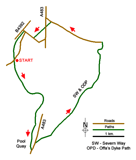
This Powys walk, located north of Welshpool off the A483, explores a section of the Montgomery Canal and follows the Offa's Dyke Path and Severn Way along the banks of the River Severn. The canal was closed for many years and is currently under restoration with the intention to reopen the full length in due course. The many years when the canal lay out of use encouraged wildlife and today the canal is an important habitat for a range of species.
The start is the car park at the Wern Claypit Nature Reserve (grid ref. SJ251140). After parking, walk south along the canal following the towpath for just under two miles. On this section you pass Bank Lock, Cabin Lock and Crowther Hall Lock to reach Bridge 111. Just after this bridge bear left following the signs to 'Powis Arms' pub (this is just before reaching Top Lock). Follow the lane to the A483 (grid ref. SJ256114).
Turn left along the A483 following the pavement. Just pat the farm buildings on your left you will reach an Offa's Dyke/Severn Way footpath sign pointing across the road to 'Four Crosses'. Cross the road, with care, cross the stile on the left and walk half right to follow the path that runs parallel to the River Severn. The way ahead follows the River Severn (on your right) and after just over a mile joins the Tirymynach Embankment (grid ref. SJ271131) which was built as flood protection.
After a mile or so following the embankment you reach a stile and adjacent metal gate (grid ref. SJ277146) with Rhyd-esgyn Lane down to your left. Turn down to the road and go left. Follow this quiet lane for a mile keeping straight ahead at two junctions. Just before a small bridge with metal railings (grid ref. SJ262151) turn left over a stile onto an embankment. There is a path of sorts and it follows the stream on your right to reach the A483 (grid ref. SJ260150).
Cross the A483 with care as traffic can be fast on this section. Bear left to the end of a metal crash barrier and locate a stile adjacent to a metal double gate. Cross the stile and continue along the embankment. Continue across an old railway formation to reach a lane (grid ref. SJ257147). Turn right, and follow the lane past Lower House Farm to reach a road junction jest before a canal bridge (grid ref. SJ254149). Turn left down the lane and immediately bear right onto the canal towpath. Continue along the canal past Burgedin Locks and bridge 106 to regain the car park used at the start of the walk.
Messaging & Social Media
Message Walking Britain and follow the latest news.

Mountain Weather
Stay safe on the mountains with detailed weather forecasts - for iOS devices or for Android devices.