Walk 3005 - printer friendly version
Clogwen Walk
Author - Andy Smith
Length - 2.0 miles / 3.3 km
Ascent - 550 feet / 167 metres
Grade - easy
Start - OS grid reference SH727578
Lat 53.102165 + Long -3.9028606
Postcode LL24 0EF (approx. location only)
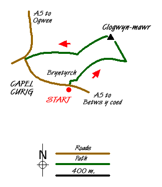
For those not wishing to do much strenuous hill walking, this short afternoon Snowdonia (Eryri) walk provides a surprisingly wild vantage point of North Wales despite its modest height of 344 metres. This route does include some mild scrambling and due to its short distance some paths mentioned are not marked on Explorer maps though easy to locate. This route is described from Bryntyrch (Grid ref. SH727578) but a start could also be made from the pay and display car park near the main road junction in the centre of the village (Grid ref. SH720582). Do ask permission if you are not using the facilities of the hotel, hostel or camp site at Bryntyrch.
Walk up the campsite drive passing the house to your left where you will find a stile immediately in front of you. Cross this and bear right behind the camping ground to another stile leading gently uphill (Grid ref. SH726581). Continue for 500 meters and take a left hand fork (not too obvious) and follow this track passing the foot of Clogwen summit.
After a few minutes a sharp vertical crag is reached. Walk past this crag and turn left uphill as you start a mild scramble. From here there is no path and you make your way up maintaining a straight line heading towards the tree high above. Once the tree is reached bear very slightly right and head for the summit which soon comes into view. At times you can be tempted to take other routes but by following this guideline it is unlikely you will have to use your hands more than twice.
Once on the summit you can enjoy superb views of the Ogwen valley to your right, to your left is Moel Siabod and in front Snowdon dominates the picture. On a fine day this makes a grand place to relax and have a lunch break.
When ready, leave the summit to the west dropping down towards the wall from where the descent path comes into view. Continue steeply downhill. Within 10 minutes a major track crosses your path. Turn right here and follow along though the woods to the A4086 junction. There is a shop, café and public toilets here if you wish to avail yourself of these facilities. Once ready simply make your way along the A5 main road towards Betws-y-coed. This takes you back to the start after a short but rewarding afternoon walk.
Messaging & Social Media
Message Walking Britain and follow the latest news.

Mountain Weather
Stay safe on the mountains with detailed weather forecasts - for iOS devices or for Android devices.