Walk 3006 - printer friendly version
Cautley Spout & The Calf Walk
Author - Lou Johnson
Length - 5.5 miles / 8.9 km
Ascent - 1990 feet / 603 metres
Grade - moderate
Start - OS grid reference SD698969
Lat 54.366713 + Long -2.4663081
Postcode LA10 5NE (approx. location only)
This is a fairly straightforward excursion into the Howgills including its most dramatic locations combined with a visit to the Calf, which is the highest point in these rounded hills. It does have two sections over open fellside with no clear paths so you do need to be competent at route finding. This is especially true if the visibility is poor as the Howgills are notorious for their complicated ridges and valleys.
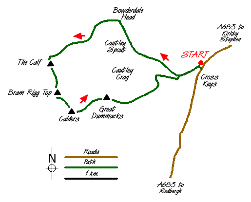
The start is in the small lay-by at Cross Keys (grid ref. SD698969) on the A683 Sedbergh to Kirkby Stephen road. The lack of parking must be stressed although this has the advantage that you will see few other walkers for most of the route. From the lay-by take the signed footpath to Cautley Spout. The path descends to a footbridge over the River Rawthey. Cross over and turn left and continue alongside the river for a short way until Cautley Holme Beck comes in from the right. Turn right here and continue on the east side of this stream. The path climbs gently at first with the mile long Cautley Crag an imposing feature on your left. At its northern end you will see Cautley Spout, a dramatic waterfall, which after heavy rain is often spectacular.
The path climbs more steeply and when you get near to the base of the waterfall a decision needs to be made on the route to the Calf. There is a path on the right hand side of Cautley Spout and you can use this to climb steeply onto the fellside above the falls. Reaching the top you follow Swere Gill in a westerly direction to reach the main ridge path. An easier way of reaching the same objective is to continue on the main path until you reach the col above Bowderdale Head. At the highest point of the Col turn left and climb due west up the grass. This will lead you to the main ridge path.
On reaching the main ridge path turn left and this will bring you to the OS trig point at the summit of the Calf. From here the views are superb, especially the complex structure of ridges and valleys that make up the Howgill Fells. Leave the summit on the main path leading south. A short descent and ascent lead to the summit of Bram Rigg Top with a similar switchback taking you onto Calders.
Ignore the main path that leads off this summit in a south-westerly direction to Sedbergh instead turn east and follow the fence, which is on your right. Reaching the end of the fence continue in the same direction to reach the fourth summit of the walk - Great Dummacks. Care is now needed and it is important that you are aware of the potential danger that lies ahead - notably Cautley Crag. It is important that you leave Great Dummacks in a south-easterly direction and you take care not to trend north at least until you have lost some height.
The descent is over grass. The fellside is steep and you have a superb view down to the River Rawthey, which lies far below. Once you are sure that you are clear of danger trend left (north) to pick up Pickering Gill, which can then be followed down the fell to reach a walled field near a barn. Here you will pick up the valley path from Sedbergh. Turn left and cross the bridge. You are now on the path used for the outward leg of the route and turning right across the next footbridge you are back at the lay-by.
Messaging & Social Media
Message Walking Britain and follow the latest news.

Mountain Weather
Stay safe on the mountains with detailed weather forecasts - for iOS devices or for Android devices.