Walk 3010 - printer friendly version
Stob Dearg (Buachaille Etive Mor) from Altnafeadh Walk
Author - Lou Johnson
Length - 4.0 miles / 6.5 km
Ascent - 2500 feet / 758 metres
Grade - mod/hard
Start - OS grid reference NN221563
Lat 56.66454 + Long -4.9044499
Postcode PH49 4HY (approx. location only)
This mountain has gained almost iconic status and is a familiar sight to all those travelling the A82 between Tyndrum and Fort William. Although this summit presents a pyramid like shape it is in fact the end buttress of a ridge that attracts the name of Buchaille Etive Mor.
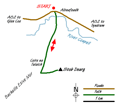
This route starts from Altnafeadh (Grid ref. NN221563) where parking is available in parking areas on both sides of the road. After parking head south along the track that leads across a bridge over the River Coupall towards the white cottage of Lagangarbh.
Beyond the cottage the path forks where you take the right hand path. The ascent begins in earnest now with the crags of Stob Dearg soaring skywards. The path crosses the Allt Coire na Tulaich and remains on the west bank of this burn. Continuing upwards into dramatic Coire na Tulaich the path steepens with the coire wall looking daunting.
However no technical difficulties are met and the ascent eases to reach a col (Grid ref. NN 216542). Turn left (east) and continue the climb to reach the summit of Stob Dearg. Apparently there are superb views, which on this ascent were not in evidence with rain lashing across the hill.
The descent follows the outward route although care is needed for the first steepish section down into Coire na Tulaich.
Messaging & Social Media
Message Walking Britain and follow the latest news.

Mountain Weather
Stay safe on the mountains with detailed weather forecasts - for iOS devices or for Android devices.