Walk 3018 - printer friendly version
Cracknowl and the Monsal Trail Walk
Author - Jake Robertson
Length - 3.5 miles / 5.7 km
Ascent - 300 feet / 91 metres
Grade - easy
Start - OS grid reference SK223689
Lat 53.216693 + Long -1.667504
Postcode DE45 1GE (approx. location only)
This is a very gentle Peak Dsitrict walk along the Monsal Trail and over an unassuming but unexpectedly lovely hill pasture. It's an idyllic hour or so escape from the crowds in Bakewell with some beautiful views over the town and surrounding countryside and the Derbyshire Dales.
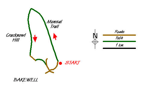
Park at the Monsal Trail car park at Bakewell Station on Castle Hill (grid ref. SK223689). Walk past the station buildings and turn left onto the Monsal Trail. Follow the trail for about 1 ½ miles until you near the Toll Bar House. It's flat all the way with views opening out towards Longstone Edge once the bookshop and café at Station Farm is passed. Take a walled bridleway on the left (grid ref. SK214707), signposted to Bakewell, and climb gently onto the pasture. After a short climb it undulates for about half a mile to reach the high point at 210m (grid ref. SK 214697).
Although not explicitly named on the maps I've taken to calling this hilltop Cracknowl Hill, it certainly deserves a name. Shy and unobtrusive it does have a quiet charm about it and is a delightful viewpoint for the higher surrounding hills. The view south over Bakewell with it's church spire sticking out of the trees with the mass of Stanton Moor rising impressively to the south is especially good.
Continue along the track which begins to descend, passing though an open field with many fine picnic spots, to a gate. Through the gate the track becomes metalled and there's a steep but short drop down to the road (Holme Lane) by River Wye (grid ref. SK215690). Turn left for a short way until you can take a path on the right down by the riverbanks which is followed underneath the main road to the road bridge (grid ref. SK219687). Cross the main road onto Station Road with the car park only a short five minutes climb at the top of the road.
Messaging & Social Media
Message Walking Britain and follow the latest news.

Mountain Weather
Stay safe on the mountains with detailed weather forecasts - for iOS devices or for Android devices.