Walk 3028 - printer friendly version
Tarn Hows & Tom Gill Walk
Author - Lou Johnson
Length - 6.5 miles / 10.6 km
Ascent - 1200 feet / 364 metres
Grade - easy/mod
Start - OS grid reference SD303975
Lat 54.368225 + Long -3.0743014
Postcode LA21 8EL (approx. location only)
Tarn Hows is often featured as one of the scenic beauty spots of Lakeland. Its beautiful setting and the surrounding mountain panorama justify its popularity. This Lake District walk enables you to experience Tarn Hows and combines this scenic attraction with the busy regional centre of Coniston. The route uses generally well maintained paths although the tricky descent beside Tom Gill can be slippery in wet weather.
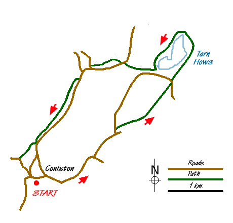
The start is the main pay and display car park (Grid ref SD303975) in Coniston adjacent to the Tourist Information office. Exit the car park and turn right along the B5285 to Hawkshead. The footpath passes Waterhead and follows the road as far as the entrance drive to Boon Crag Farm (grid ref. SD316983). Pass the entranceway and continue on the footpath beside the road to a T-junction (grid ref. SD318984). Turn left and after crossing a small stream, cross the road and take the signed path on the right through the woods towards Tan Hows. At grid ref. SD326989 the path splits. Take the right-hand fork to the upper car park above Tarn Hows.
Reaching the road (grid ref. SD330995), cross over and take the clear high level path ahead. Down on your left you will see Tarn Hows with the lower path on its shore. The higher path gradually descends to join the lower path on the side of the Tarn. Continue walking, with the Tarn on your left, and make an almost complete circuit of the lake until you reach the outfall of Tom Gill (grid ref. SD327998). The path descends on your right just before Tom Gill, with the stream remaining on your left for most of the descent. Care is needed as in places this path can be awkward in descent especially after rain or snow.
The path leads down to the main road from Ambleside to Coniston (grid ref. SD321999). Turn left towards Coniston and follow the path in the field adjacent to the left-hand side of the main road. Cross the road (grid ref. SD320998) towards Yew Tree Farm and take the signed track. Reaching a junction, bear left along a walled track to cross the Holme Ground and Tilberthwaite roads. The onward path is clear and well signed and should be followed all the way back to Coniston.
Messaging & Social Media
Message Walking Britain and follow the latest news.

Mountain Weather
Stay safe on the mountains with detailed weather forecasts - for iOS devices or for Android devices.