Walk 3039 - printer friendly version
Holyhead Mountain Walk
Author - Lou Johnson
Length - 4.5 miles / 7.3 km
Ascent - 1100 feet / 333 metres
Grade - easy/mod
Start - OS grid reference SH211818
Lat 53.302854 + Long -4.6862431
Postcode LL65 1YH (approx. location only)
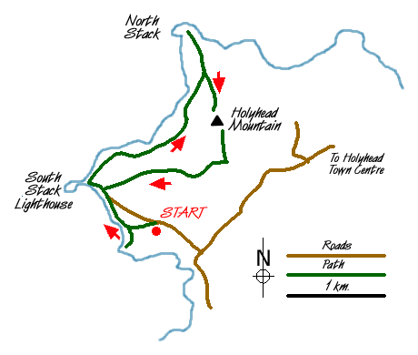
Although relatively short in length this walk combines a superb section of coastal walking and some modest but rough mountain terrain near to Holyhead on Anglesey. The start is the small car park (grid ref. SH211818) located roughly 4 km west of Holyhead town centre.
Exit the car park on the clear path heading southwest towards the cliffs. Reaching the coastal path it is worth the extra effort to turn left and walk down towards Pen-las Rock before retracing your steps and continuing north towards the Seabird Centre - a small whitewashed building. Throughout the year this area is a Mecca for those interested in birds and on the day the walk was researched a rare visit by a Gyr Falcon was the centre of interest for many visiting this headland.
The path continues close to the top of the cliffs to reach South Stack with its dramatically located lighthouse. During the summer months you can visit the lighthouse using the steep steps and bridge to reach the small island on which it is located. Staying on the path closest to the cliffs continue north eastwards with steep cliffs on your left. There are many paths so do be careful and avoid one which drops down to the shoreline with no onward continuation.
The path is easy and you will enjoy the sea birds that seem to congregate in force along this section of coast. Turning north the path descends to North Stack with its small signal station and this makes a pleasant spot to have a break. The next objective is the summit of Holyhead Mountain, the highest point on Anglesey at 220 metres above sea level, and this is easily reached by making a direct approach up the indistinct north ridge. From the summit there are excellent views especially over Holyhead with its harbour and extensive breakwater.
Holyhead Mountain, despite its small stature, actually feels like a mountain and it does offer some good but limited climbing and scrambling. The easiest descent is to head south off the summit to pick up a wide path leading west. This leads back to South Stack from where the coast path offers the best route back to the car park.
Messaging & Social Media
Message Walking Britain and follow the latest news.

Mountain Weather
Stay safe on the mountains with detailed weather forecasts - for iOS devices or for Android devices.