Walk 3050 - printer friendly version
Clun circular Walk
Author - Lou Johnson
Length - 11.5 miles / 18.7 km
Ascent - 2050 feet / 621 metres
Grade - moderate
Start - OS grid reference SO299808
Lat 52.420679 + Long -3.0322141
Postcode SY7 8JR (approx. location only)
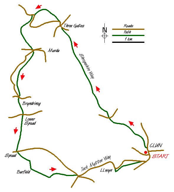
This route explores pleasant rolling Shropshire countryside the northwest of Clun. It includes sections of the Shropshire Way, Offa's Dyke National Trail and the Jack Mytton Way. Route finding is generally good although the first section leaving Clun is poorly way-marked, a fact that is sadly true of much of the Shropshire Way.
The start is the pay-and-display car park (Grid ref. SO299808) adjacent to the bridge over the River Clun. Cross the footbridge into the Castle grounds. Continue, with the ruins on your left, to the main exit by the bowling green and cross the stile on your left. You are now on the Shropshire Way. This path leads to a lane (Grid ref. SO 298811). Walk north along the lane to its end. The path crosses the river and the follows the stream for some way before veering half left to join a green lane. This leads to a lane (Grid ref. SO 286819).
Cross the lane and continue on the Shropshire Way. The path climbs, steeply at first, before continuing more steadily across pastures along a broad ridge named Cefns. In places the route is ill-defined and some care is needed to stay on the path with the 1:25000 map recommended. The path leads down to a green lane which in turn joins a lane (Grid ref. SO 270850).
Continue down this lane and go straight across at the cross-roads at Three Gates. Approximately 200 metres after the cross-roads take the footpath on your right (Grid ref. SO 270852). This climbs across the northern flanks of Hergan to reach a junction of paths (Grid ref. SO 261854). Turn left to leave the Shropshire Way and head south on the Offa's Dyke National Trail. Cross the lane and continue on the Trail as it descends into a valley. Reaching a lane (Grid ref. SO 260843) turn left and then right. Locate the continuation of the path which goes off left climbing once more across the flanks of Graig Hill.
Evidence of the Dyke is to be seen from now on with remains of this lengthy ditch still easily recognised. You will have realised that the Offa's Dyke Trail is a switch-back and after a steady climb you descend again into the Clun Valley (Grid ref. SO 256286). Cross the road and continue on another path to a footbridge and the B4368 at Lower Spoad. Take the track to the left of the farm buildings and start to climb again. Behind you can see where you have just walked across the Clun Valley.
The path follows the Dyke to reach Springhill Farm (Grid ref. SO 255808). Cross the road and, leaving the Offa's Dyke Trail, take the footpath that leads through the left-hand gate opposite. The path goes half left across the this field and maintains a similar direction across more field to reach a track. Turn left (east) and follow this track past Burfield to reach a cross-roads (Grid ref. SO 276800).
Turn left (sign posted Clun) and follow this quiet lane, which forms part of the Jack Mytton Way. The road descends gently with views across the valley to the first sections of the walk. Reaching Peartree Cottage turn right off the lane and through a gate. This leads into a wide green path that will lead you down into Clun.
Messaging & Social Media
Message Walking Britain and follow the latest news.

Mountain Weather
Stay safe on the mountains with detailed weather forecasts - for iOS devices or for Android devices.