Walk 3055 - printer friendly version
Glasgwm Walk
Author - Lou Johnson
Length - 4.5 miles / 7.3 km
Ascent - 2375 feet / 720 metres
Grade - moderate
Start - OS grid reference SH852188
Lat 52.751004 + Long -3.7008201
Postcode SY20 9JG (approx. location only)
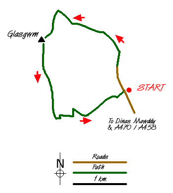
Occupying an excellent position towards the southern end of the main Aran ridge, Glasgwm provides an excellent objective for a short Snowdonia (Eryri) walk in the mountains. However despite its length the ascent is continuous and the descent quite steep. However considering the short length there is much to see and enjoy. To reach the start, turn off the A458 Welshpool to Dolgellau road at Dinas Mawddwy and follow the narrow lane up the beautiful valley of Cwm Cywarch to reach a signed car park at grid ref. SH852188.
Continue up the lane following the signed path past Blaencywarch Farm, which nestles beneath the awesome crags of Cwm Cywarch. Please take care that you follow the signed path which by-passes the farm before heading left of a smooth rock outcrop. The climbing now begins in earnest and you gain height quickly with the crags closing in around you. During the ascent you cross the stream twice and can enjoy some small waterfalls and the immediate surroundings, which are superb.
As height is gained the retrospective view improves and the col beneath Glasgwm is soon reached (grid ref. 841201). Here the path levels and you reach a small tarn. Ahead there are excellent views north to the Rhinog mountains with Aran Fawddwy rising to almost 3000 feet on your right. Ignore the path to the latter summit and, keeping the tarn on your right, follow the fence on your left to reach a stile. Cross this and turn left to follow the fence uphill. Height is gained quickly and the summit of Glasgwm is soon reached with the fence acting as a guide all the way to the top. The highest point is marked by a large beehive cairn with the large tarn just below the summit on the southern flank coming as a surprise. This spot provides a superb place to enjoy the excellent view and take a rest.
Leave the summit in a southerly direction crossing a ladder stile before heading for an obvious rocky outcrop. A clear path leads you onward with a fence coming in from your right. Keeping the fence on your right continue across open moorland. The path then descends quite steeply over grass to reach a col. Note - to your left are steep crags so care is needed on this section. Ahead you will see a stone track descending steeply down to the left. Join this track and head down into Cwm Cywarch. The going is steep in places although well constructed zigzags mean an easy and fast descent into the valley and the start of the walk.
Messaging & Social Media
Message Walking Britain and follow the latest news.

Mountain Weather
Stay safe on the mountains with detailed weather forecasts - for iOS devices or for Android devices.