Walk 3056 - printer friendly version
Pen yr Helgi Du from Ogwen Valley Walk
Author - Lou Johnson
Length - 5.5 miles / 8.9 km
Ascent - 1920 feet / 582 metres
Grade - moderate
Start - OS grid reference SH687602
Lat 53.122756 + Long -3.963551
Postcode LL24 0EU (approx. location only)
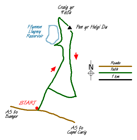
This is an ideal route for a half day excursion into the hills. The Carneddau are wild and desolate lying to the north of the A5 between Bethesda and Capel Curig. Limited parking is available at the entrance to the reservoir access road (Grid ref. SH687602) or if this is full then across the road Gwern Gof Isaf farm where a small charge is payable.
Walk up the reservoir access road climbing steadily for about 1.5 miles gaining nearly a thousand feet in the process. The road levels and drops down to Ffynnon Llugwy Reservoir, the shores of which make an ideal place to rest. Retrace you steps a short way to pick up the path that heads north along the eastern side of the reservoir. This path starts to climb up to the obvious col ahead. Zigzags at an easy gradient lead to the Col with the crags of Craig yr Isfa plunging into Cwm Eigiau far below.
At the Col turn right along a clear path. This climbs steeply through crags (with some scrambling) to lead you to the summit of Pen yr Helgi Du. The views are excellent in all directions with Carnedd Llewelyn, the highest point in the Carneddau, to the west.
Descend almost due south off the summit to follow a clear path that descends gently over a broad grassy ridge to reach a drainage channel (Grid ref. 700 607). Turn right along this channel to reach the outward route. Turn left and descend back to the start.
Messaging & Social Media
Message Walking Britain and follow the latest news.

Mountain Weather
Stay safe on the mountains with detailed weather forecasts - for iOS devices or for Android devices.