Walk 3058 - printer friendly version
Llyn yr Adar & Llyn Edno from near Bethania Walk
Author - Lou Johnson
Length - 9.0 miles / 14.6 km
Ascent - 2500 feet / 758 metres
Grade - moderate
Start - OS grid reference SH631483
Lat 53.014445 + Long -4.0421125
Postcode LL55 4NL (approx. location only)
This Snowdonia (Eryri) walk takes you into some wild country that can be notoriously difficult for navigation even when the weather is fine. After heavy rain it would be hard to keep your boots dry and dogged determination might be required in addition to good compass skills. Having said this the walk is a delight and if the weather is fine you will be rewarded with grand views of Snowdon.
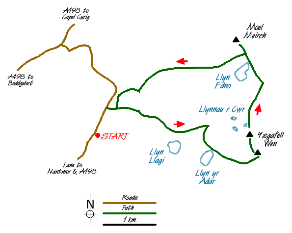
There is parking available in a small lay-by (Grid ref. SH631483) which is reached by taking the minor road that leaves the A498 at Bethania. After parking walk north along the road and follow the signed path on your right that leads past a cottage and continues to reach a house named LLwynyrhwch on the OS map. The path goes to the left of this house and begins the climb up to Llyn Llagi, which is the first objective of the route.
The path is easy to follow and climbs steadily to reach a ruined barn. Shortly afterwards you get you first view of Llyn Llagi nestling beneath steep crags. The path does not head to the shore but trends west past evidence of mining climbing steadily up a valley. About 500 metres past the lake look out for a feint path that heads south up through the crags towards Llyn yr Adar. Don't worry if you miss it as you can easily find your own route through the rocks and grass.
Reaching Llyn yr Adar you will see Cnicht to the southwest looking rather less dramatic from this angle. There is an onward path that heads southeast before trending east to reach the Ysgafell Wen ridge near Llyn Terlyn (Grid ref. SH 669 480). Turn left along the fence with worthwhile diversions to the tops of two separate cairned summits that form Ysgafell Wen. From the second (Grid ref SH 664 486) with a spot height of 669 m you get a good view of the trio of small lakes known as Llynnau 'r Cwr or the Dog Lakes.
Keeping with the path that heads north following the fence, you reach Llyn Edno a classic mountain lake surrounded by wild country and crags. Whatever the weather this a wonderful place to linger to enjoy the solitude. Continue along the fence to reach a small col on your left. This is the way back to the car but a worthwhile diversion is a visit to the summit of Moel Meirch which offers an excellent view north.
From the Col a path develops and fades. Afon Llynedno will be crossed and from this point onwards you need to keep this river on your right. The path does not drop down to follow the river but stays high. In places the route is not clear but with careful navigation you should arrive at a wall (Grid ref. SH 644 497) where a ladder stile leads you onwards to pass Hafodydd Brithion and gain the farm drive that leads back to the road. Turn left along this road to return to the parking area.
Messaging & Social Media
Message Walking Britain and follow the latest news.

Mountain Weather
Stay safe on the mountains with detailed weather forecasts - for iOS devices or for Android devices.