Walk 3070 - printer friendly version
Knock Fell & High Cup Nick Walk
Author - Lou Johnson
Length - 12.0 miles / 19.5 km
Ascent - 2500 feet / 758 metres
Grade - mod/hard
Start - OS grid reference NY689249
Lat 54.618284 + Long -2.4831188
Postcode CA16 6DE (approx. location only)
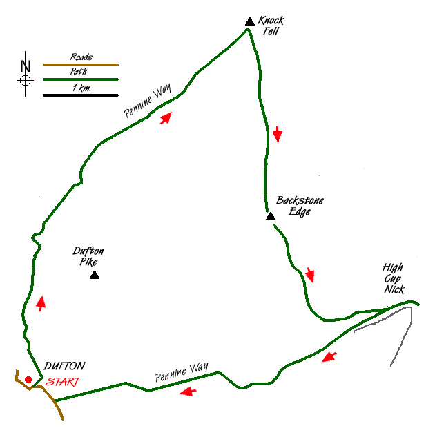
This walk includes two lengthy sections of the Pennine Way and a section of cross country walking where no path is visible on the ground. The high fells in this area are subject to rapid changes in weather so be prepared for crossing difficult terrain and be able to use a map and compass or other navigational aid.
The start is the village of Dufton (Grid ref. NY689249). There is a small carpark and on street parking although please ensure you do not obstruct access. From the car park exit onto the road and turn right. The village green is on your left. Continue along the road past the large house on your left built in 1779 and continue straight ahead on the Pennine Way. After a short way the path goes left (Grid ref. NY 691 252) and continues through farmland to reach a lane. Turn right along this lane and stay on the Pennine Way for approximately a mile. Reaching a bridge over Great Rundale Beck (Grid ref. NY 692 273) continue on the track as it gently climbs the fellside.
The Pennine Way is clear and well waymarked and despite the uphill work you make good progress as your climb steadily with ever improving views to your left. On reaching the Knock Old Man (Grid ref. NY 720 300) continue a short way to the summit of Knock Fell. There is a good view ahead to Great Dun Fell and beyond to Cross Fell.
The next section is pathless and you need to be careful as there are some boggy sections. The next objective is the 692 m. trig point on Backstone Edge (Grid ref. NY 725 275) and the best approach was to head just east of south working around the boggy sections but taking care to maintain the general bearing. At about NY 722 281 you drop down into a gully to cross a track that leads east to Great Rundale Tarn before climbing up across rough ground to reach Backstone Edge.
Continue south along the edge ensuring that you do not lose too much height and also making sure that you do not go too far onto the flat plateau to your left as you will lose the views across the Vale of Eden. There is an intermittent path of sorts and this leads you roughly south at first before turning east to provide you with a spectacular view of High Cup Nick. Find a suitable spot and descend on grass towards the Nick.
Having enjoyed this spectacular location turn west and follow the Pennine Way as it descends to Dufton. This is a well blazed trail and there is no danger of getting lost so a detailed description is superfluous! Reaching a tarmac lane at Town Head (Grid ref. NY 694 247) turn right and follow the lane back into Dufton village.
Messaging & Social Media
Message Walking Britain and follow the latest news.

Mountain Weather
Stay safe on the mountains with detailed weather forecasts - for iOS devices or for Android devices.