Walk 3080 - printer friendly version
Arundel Park and the River Arun Walk
Author - Lou Johnson
Length - 7.2 miles / 11.7 km
Ascent - 600 feet / 182 metres
Grade - easy/mod
Start - OS grid reference TQ020071
Lat 50.8544310 + Long -0.5522890
Postcode BN18 9PA (approx. location only)
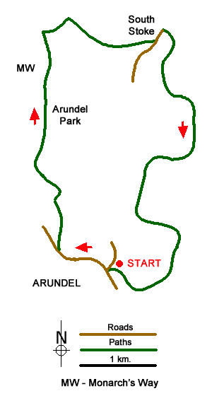
This walk allows you to explore the castle, cathedral and lovely High Street of Arundel before venturing into the surrounding countryside to enjoy Arundel Park and the River Arun. The start is the car park beside the river (grid ref. TQ020071) which is easily reached from the A27 bypass.
After parking, walk into the centre turning right into High Street. Continue up High Street with the Castle to your right. Continue into London Road passing the Cathedral on your left. The route leaves London Road at grid ref. TQ013073 where you branch to your right to follow the Monarch's Way into Arundel Park. The route crosses Arundel Park and you should stay on the Monarch's Way which is generally well signed. You pass Hiorne Tower to your left.
The path through the Park is undulating and leads you north to eventually enter South Wood (grid ref. TQ012098). Continue following the Monarch's Way down through the wood to reach a junction of paths beside the River Arun (grid ref. TQ014103). Here leave the Monarch's Way and follow the path south with the River Arun to your left and continue to South Stoke.
Reaching the lane through South Stoke, turn left and continue to the bridge over the river. Do not cross the river, instead dropping down to follow the clear path along the river bank. All that remains is to continue along the river for about 3 miles until you reach the start of the walk on the outskirts of Arundel.
Messaging & Social Media
Message Walking Britain and follow the latest news.

Mountain Weather
Stay safe on the mountains with detailed weather forecasts - for iOS devices or for Android devices.