Walk 3086 - printer friendly version
Pen y Garn from near Devil's Bridge Walk
Author - Lou Johnson
Length - 6.8 miles / 11.1 km
Ascent - 1250 feet / 379 metres
Grade - easy/mod
Start - OS grid reference SN765755
Lat 52.3635950 + Long -3.8151446
Postcode SY23 4AB (approx. location only)
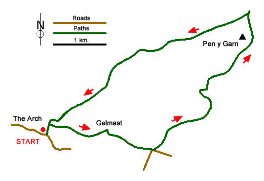
The Cambrian Mountains were once considered as a possible National Park. Sadly, the proposal never went ahead and this area of rounded hills and wild country remains relatively unvisited. This walk features the summit of Pen y Garn which rises to 2001 feet above sea level (610 metres) and can be easily reached from the car park (grid ref. SN765755) close by the Arch on the B4574 east of Devil's Bridge.
After parking take the signed footpath leading along a track from the northern end of the car park. After just over 100 metres you reach a junction of tracks. Turn right here and follow the clear route to reach Gelmast. 250 metres after passing Gelmast, their access road bends to the right and meets another track. Turn left here and almost immediately right (grid ref. SN778755) onto a footpath heading south east through a plantation. This path leads to a lane (grid ref. SN783752). Turn left along the lane and where the lane bends to the right continue straight ahead on a path and then track following the boundary of the forest.
After 400 metres you reach a T-junction with a wider track (grid ref. SN786756). Turn right here and follow the track to the end of a small plantation on your left (grid ref. SN792759). The track divides here. Take the right-hand track and continue through another plantation, through two hairpin bends. Some 300 metres after the second hairpin, bear right off the main track to take a less-used shortcut back to the main track (grid ref. SN795766). Following the main track continue straight ahead at the next junction, and follow the track round to the left at the next junction (grid ref. SN797766). The walk's objective is getting close and after 400 metres you can make a beeline to the trig point and stone shelter on the summit of Pen y Garn which lies to the left of the track.
After enjoying the view, return to the track and continue heading north. You start to descend passing two wind turbines on your left. Just after the second turbine, turn left onto a clear track that leads through the forest. Keep straight ahead ignoring a track going off left to reach a second junction with open land to your right (grid ref. SN786771). Continue straight ahead here, ignoring the track to your left. After 600 metres you reach another junction. Bear right here and shortly after at the next junction (grid ref. SN778768) go straight ahead. Stay on this clear track all the way back to the start.
Messaging & Social Media
Message Walking Britain and follow the latest news.

Mountain Weather
Stay safe on the mountains with detailed weather forecasts - for iOS devices or for Android devices.