Walk 3109 - printer friendly version
Rylstone Edges & Cracoe from Rylstone Walk
Author - Allan Friswell
Length - 6.0 miles / 9.8 km
Ascent - 1100 feet / 333 metres
Grade - easy/mod
Start - OS grid reference SD969586
Lat 54.023389 + Long -2.0488082
Postcode BD23 6LH (approx. location only)
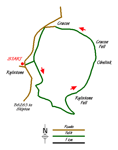
You start this Yorkshire Dales walk in Rylstone, home of the original WI Calendar Girls, your car probably parked close by their 1994 tree by the pond (grid ref. SD969586). From here cross the main road and head up the lane opposite, passing the Manor House on the right (whose Spring gardens are full to bursting with snowdrops) and make for the church. Just beyond this turn right along a rough track, which you follow across a couple of fields to a second clear track. Turn left and follow this track to a gate on the left - the access area entry point. Follow the track through the reedy pasture, climbing steeply past a small plantation to a gate. From here the access area proper is entered. Continue up the track and when you arrive at a gate turn sharp left and walk up to the summit, keeping the wall on your left. From here make your way to Rylstone Cross. (Try as I may I cannot find any online history to portray the cross, only that it was rebuilt in 1995!)
Walk along the moor-side (east) of the wall following a well-worn path which undulates but gradually climbs the extra 350' to reach another stile giving access to the obelisk after about 20 minutes. This is Cracoe's memorial to their men who died in the two World wars, with their names carved into the Yorkshire gritstone. As from the Cross, the views are magnificent.
The next bit is trickier as it is not marked on the OS map. Head along the slope from the obelisk parallel with the wall over to the right, along a faint trod. This, after a couple of hundred yards, turns sharply left, and becomes much more defined, a huge sled groove down which stone was one transported. The descent becomes very steep indeed before approaching a marshy area of taller grasses. You can try following the apparently obvious path ahead, but my advice is, before you reach this Slough of Despond, you should leave the path and skirt left around the top of this marshy area. You will come to a small stream after about 100 yards - cross it and turn right. You should be opposite a distant walled green lane (see picture). At this point you should be able to walk relatively unscathed by deep water to the sheep pens and gates to the lane.
The green lane shortly becomes a farm track. At a cottage it becomes surfaced and just before reaching the main road, at the access point notice, you turn left along a narrow lane. Go right at its end, then sharp left again as it runs behind the 'Devonshire Arms'. At a junction at the end keep straight on alongside a stream. At the main road, turn left and follow the walled lane of Chapel Lane. This quickly levels out and makes towards Rylstone. By the trees at the end take the gate ahead. Proceed along the wall side to Manor House Farm on the right and ponds on the left. From a gate at the end the lane-head at the start of the walk is rejoined. Follow it back past the church to the pond.
Messaging & Social Media
Message Walking Britain and follow the latest news.

Mountain Weather
Stay safe on the mountains with detailed weather forecasts - for iOS devices or for Android devices.