Walk 3130 - printer friendly version
Scafell Pike via Esk Hause from Seathwaite Walk
Author - Lou Johnson
Length - 8.0 miles / 13 km
Ascent - 3100 feet / 939 metres
Grade - mod/hard
Start - OS grid reference NY235121
Lat 54.4984300 + Long -3.1827147
Postcode CA12 5XJ (approx. location only)
An ascent of Scafell Pike, England's highest mountain, is a very popular Lake District walk undertaken by many thousand walkers each year. The walk is straightforward provided you have good comfortable footwear, an appropriate map. clothing suitable for the anticipated weather and a supply of drinks and food. However, in winter conditions with snow and ice on the fells it becomes a more serious undertaken and should only be attempted by experienced walkers.
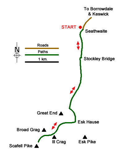
The start is Seathwaite (grid ref. NY235121) where parking can be problematic on busy days. After parking walk through the farmyard and take the main path south to Stockley Bridge (grid ref. NY234109). Cross the bridge and turn immediately left along the path on the west side of Grains Gill. The path climbs steadily beneath Sprinkling Crags to your right and the slopes of Allen Crag to your left. Reaching the top a ravine, the path joins a path coming in from Sprinkling Tarn on your right and heads south-east (left) alongside Ruddy Gill. Stay on this path for 300 metres to reach a fork (grid ref. NY231085).
Take the right-hand fork and climb up to reach a junction of paths at Esk Hause (grid ref. NY232081), which can be confusing in low cloud. Turn right here and continue across the southern slopes of Great End which is to your right. The ascending path continues to cross the gravelly wastes of Ill Crag, with Scafell Pike coming into view for the first time, before descending to a col with a further climb over rock strewn Broad Crag. Sadly, a further loss of height follows as you descend into a rocky col before continuing ahead to the rough and rocky summit of Scafell Pike (grid ref. NY215072) with its wind shelter and obligatory OS trig column. In clear weather the view is excellent with many of the Lakeland peaks in the 36 degree panorama.
The return route follows the outward route. If the weather worsens then for the most part the route across Broad Crag and Ill Crag to Esk Hause has enough cairns as navigation aids. In low cloud Esk Hause can be confusing and it is important that you bear left and continuing descending north. Having reached the top of Ruddy Gill ensure you turn right alongside the gill to continue your descent back to Seathwaite.
Messaging & Social Media
Message Walking Britain and follow the latest news.

Mountain Weather
Stay safe on the mountains with detailed weather forecasts - for iOS devices or for Android devices.