Walk 3131 - printer friendly version
Thorpe Cloud and the Dove Valley Walk
Author - Lou Johnson
Length - 1.6 miles / 2.6 km
Ascent - 600 feet / 182 metres
Grade - easy
Start - OS grid reference SK146508
Lat 53.0542590 + Long -1.7836321
Postcode DE6 2AY (approx. location only)
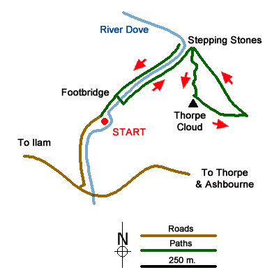
This Peak District walk in lower Dovedale is short and climbs to the top of Thorpe Cloud. This small hill is an ideal ascent for children and grand-children as it looks like a real 'mountain'. The hike includes a section of the River Dove, stepping stones across the river and a climb up the hill which includes a few sections of easy scrambling to keep the children interested. The view from top is excellent. Note this walk is not suitable for pushchairs.
The start is the Dove Valley Car Park located on the north side of the lane from Ilam to Thorpe and easily reached from Ashbourne (Grid ref. SK146508). There are charges to park with toilets and refreshments available. After parking walk, back to the exit and turn right on a tarmac track or the parallel path which runs closer to the river (which is on your right). Continue upstream to reach a footbridge. In season ice creams are available here together with National Trust information about the Dove Valley parts of which they manage.
Reaching the footbridge on the right, cross the river. Once on the other side, turn left and continue along a rougher path upstream. The views up the valley improve and you soon reach the stepping stones which will be crossed on the way back to the car park. Just past the stepping stones turn right onto the first path. After a few metres, you will see a rocky gully on your right. This is the start of the path to the top of Thorpe Cloud. Alternatively continue a little further and take an easier path also on your right. Continue up the clear pack encountering several rocky sections soon gaining height.
Reaching the top, you will find a ridge running north-west to south-east. Before you start to explore take note of the descent path which goes down to the left shortly after the ascent path arrives at the summit. Spend some time enjoying the view but do make sure children are aware of the steep drop down to the river. Apart from this the summit area is generally safe.
To descend follow the path noted on your arrival at the top and descend more easily down to the bottom. Reaching level ground, bear left and with Thorpe Cloud on your left continue along a grassy path down the shallow valley and back to the River Dove. Cross the River Dove using the stepping stones and turn left downstream back to the start. If you look up to the left you can see the summit of Thorpe Cloud high up above you. Perhaps a welcome ice-cream or some refreshments to finish the expedition?
Messaging & Social Media
Message Walking Britain and follow the latest news.

Mountain Weather
Stay safe on the mountains with detailed weather forecasts - for iOS devices or for Android devices.