Walk 3133 - printer friendly version
Ullscarf and Watendlath from Stonethwaite Walk
Author - Lou Johnson
Length - 10.0 miles / 16.3 km
Ascent - 2700 feet / 818 metres
Grade - mod/hard
Start - OS grid reference NY262137
Lat 54.5132070 + Long -3.1414353
Postcode CA12 5XG (approx. location only)
From below, Ullscarf is surrounded by impressive crags, especially when viewed from the surrounding valleys. However, the true character of the fell changes above 2,000 feet to reveal easy grassy slopes rising to the summit. It is worth pointing out that in places it can be wet underfoot although this is compensated by beautiful valley approaches and views from the summit that include many Lakeland fells.
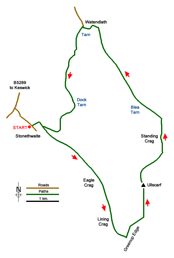
The start of this Lake District walk is the attractive village of Stonethwaite located just to the south of the B5289 Borrowdale Valley road. Parking in the village at grid ref. NY262137 is possible on quiet days but usually you need to park in the layby about 450 metres after leaving the B5289 (grid ref. NY260139). After parking take the walled lane beside the Telephone Box and continue over Stonethwaite Beck to reach a junction of paths (grid ref. NY263138). Turn right and head up the valley rising gently to reach the footbridge at Smithymire Island (grid ref. NY274130).
Do not cross the footbridge and continue ahead following the clear path which climbs more steeply. Across the valley impressive Eagle Crag rises steeply from the valley. Continue uphill to pass Lining Crag (grid ref. NY283112) after which the gradient eases for the final pull onto the col at Greenup Edge (grid ref. NY285105). Turn left and follow the path alongside the fence line over relatively easy ground for two kilometres to reach the summit of Ullscarf.
The route continues from the summit following the fence line north. The fence soon turns northeast and then north to reach Standing Crag (grid ref. NY296134). Note that wet ground was encountered on this section and numerous deviations were necessary to avoid wet feet. From Standing Crag descend north still paralleling the old fence line to reach the bridleway from Watendlath to Thirlmere (grid ref. NY296139).
Turn left and descend past Blea Tarn to meet the path descending from High Tove down into Watendlath (grid ref. NY279163). Turn left and drop down into the village where refreshments are usually available. Cross the bridge over Watendlath Beck and follow the signed path to Dock Tarn. The path ascends easily and you soon reach the shores of the pleasantly located tarn with views over part of the route just completed. Continue on the main path southeast to Lingy End and descend steeply down into the valley. Reaching the bottom bear left to re-join the outward route. Cross Stonethwaite Bridge and return to the start.
Messaging & Social Media
Message Walking Britain and follow the latest news.

Mountain Weather
Stay safe on the mountains with detailed weather forecasts - for iOS devices or for Android devices.