Walk 3202 - printer friendly version
Postbridge & Challacombe Down from Bellever Walk
Author - Martyn Hanks
Length - 9.8 miles / 15.9 km
Ascent - 1200 feet / 364 metres
Grade - moderate
Start - OS grid reference SX665771
Lat 50.578339 + Long -3.8868653
Postcode PL20 6TU (approx. location only)
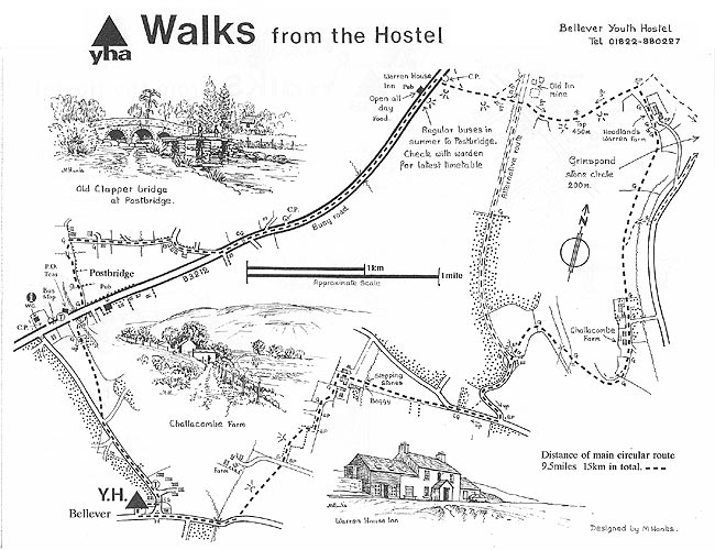
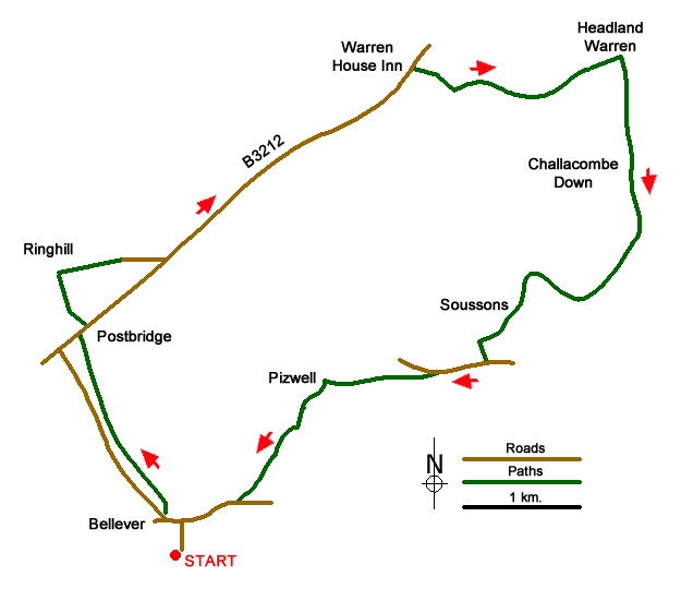
A Dartmoor walk from Bellever, exploring the village of Postbridge, with its ancient clapper bridge, Challacombe Down and Bellever Bridge. The walk starts at the parking area just to the south of Bellever at grid ref. SX665771. Generally, the route uses well-trodden paths and bridleways. However, there is a section of road walking along the B3212 which can be busy with traffic. At a good pace, this section takes about 25 minutes and there is a wide grass verge for most of the way.
From the car park walk north along the track back into the centre of Bellever. Turn left at first the T-junction at the next junction turn right along the lane towards Postbridge. Passing a row of white houses on the right, you can leave the lane and follow a bridleway running parallel to the lane. You will reach a small parking area (grid ref. SX651778). Do not take the track running right but continue parallel to the road for another 350 metres to a point where a grassy path/bridleway bears away from the lane and descends to the main road at Postbridge (grid ref. SX647789).
Turn right along the B3212. The ancient clapper bridge is on the south side of the road and well worth exploring. Return to the B3212 using the path on the east bank of the East Dart River. Cross the road and take the signed path running north. Stay on this path for 500 metres to reach a T-junction (grid ref. SX646793). Turn right (east) along a track, which soon becomes a tarmac lane and continue to the B3212 (grid ref. SX655795).
Bear left along the B3212 and using the grass verge where possible walk the 1.5 miles to reach the Warren Hose Inn (grid ref. SX674809). Shortly after you reach a small car park on the right of the road (grid ref. SX675810). Turn right through the car park and take the clear grassy track heading across the moors. After 500 metres the clear track bends to the left. Here take the footpath on the right (grid ref. SX680809), descend to a foot bridge and the remains of Vitifer Mine. Cross a broad gravel track and continue on a grassy track heading generally east to reach Headland Warren Farm (grid ref. SX693810).
Pass in front of the farm and follow their access road south. After 100 metres along the driveway, turn right onto a grassy track between buildings. This leads south across the eastern flank of Challacombe Down to reach the hamlet of Challacombe (grid ref. SX693795). Walk past the cottages to pass Challacombe Farm (grid ref. SX693794). After 250 metres the track splits (grid ref. SX691792). Take the left-hand track and follow this as it swings northwest and then south to Soussons Farm (grid ref. SX683790).
Join the access farm access drive and follow south to a lane (grid ref. SX681786). Turn right along the lane and continue past a plantation on your right. Where the road bends right (grid ref. SX677785), take the rough track leading straight ahead soon arriving in the hamlet of Pizwell (grid ref. SX668784). Follow the track leading initially west through the buildings. Almost immediately bear left and follow the track for just over 200 metres to where the track bends right (grid ref. SX666783). Here take the walled track south.
Stay on the track when it turns sharp right and then enter a field. Go half left across the field to follow another enclosed track to a track (grid ref. SX664778). Cross the track and head across rough grassland generally heading southwest to join a tarmac lane (grid ref. SX661774). Turn right along the lane, cross Bellever Bridge (with a clapper bridge to your left) and continue along the lane into Bellever. 200 metres after Bellever Bridge turn left down the access track to the parking area.
This walk is one of many routes prepared by Martyn Hanks for Youth Hostellers. The routes were drawn in a 'Wainwright' style and provided annotated maps offering additional information for walkers. Prepared before the days of GPS they were an invaluable resource and Walking Britain is happy to ensure that these walks remain in the public domain.
Messaging & Social Media
Message Walking Britain and follow the latest news.

Mountain Weather
Stay safe on the mountains with detailed weather forecasts - for iOS devices or for Android devices.