Walk 3204 - printer friendly version
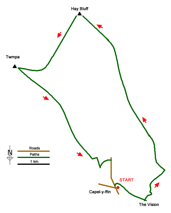
Hay Bluff & Twmpa Walk
Author - Lou Johnson
Length - 10.3 miles / 16.7 km
Ascent - 2100 feet / 636 metres
Grade - moderate
Start - OS grid reference SO254314
Lat 51.9760380 + Long -3.0874764
Postcode NP7 7NP (approx. location only)
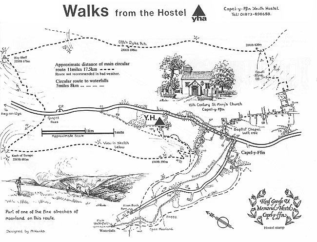
A Brecon Beacons walk from Capel-y-ffin in the Vale of Ewyas the route includes the two popular summits of Hay Bluff and Twmpa (Lord Hereford's Knob). The route includes a section of the Offa's Dyke Path, great views over the Wye Valley and some excellent walking. The return leg of the route is across less walked territory and needs careful navigation in poor visibility.
The walk starts from the roadside parking near the road junction at Capel-y-ffin (grid ref. SO254314). Initially take the main valley road north and take the first track on the right just before the chapel leading to Blaenau. Continue along the footpath across fields to reach a lane at grid ref. SO260311. Continue south-east along the track towards The Vision Farm. After passing Ty'r-onen take the next footpath on the left. This leads around the western side of The Vision and then starts to climb. Reaching open country (grid ref. SO264312) the easiest path ascends the steep hillside in a series of zigzags. After an energetic ascent the path becomes less steep and soon gains the ridge at a pile of stones (grid ref. SO270319) and the Offa's Dyke Path.
Turn left (initially northwest) along the crest of the ridge on a clear path. Continue for about 5 kilometres of easy walking on a path that undulates along the ridge. This is a wonderful walking and you can stride out and enjoy the views. Reaching the trig point on Hay Bluff (grid ref SO244366) you are rewarded with another great view west to the Wye Valley.
Leave the trig point on a clear path heading southwest with Twmpa (the next objective) in view ahead. The path descends gently at first but steepens as it descends to the road at Gospel Pass (grid ref. SO235352). Cross the road and head up the path which climbs to the cairn on Twmpa (grid ref. SO224350). This summit enjoys similar views to those enjoyed on Hay Bluff although the view to the west is somewhat better.
Leave Twmpa by following a path heading southeast. The path is intermittent in places, but you should have no problems in fine weather a small cairn on Darren Lwyd (grid ref. SO238339). From here the path heads towards a line of crags that face northeast and in poor visibility care is needed to avoid the significant drop. In fine weather you can enjoy the view across the Vale of Ewyas to the ridge walked earlier in the day. After passing the end of the crags the path trends right and follows a line on the southwestern flank of the crest before reaching steeper ground dropping away on your left (grid ref. SO248322). The path turns sharply left and then right to descend obliquely across the hillside to reach the limit of Open Access Land.
Turn left along the wall for 150 metres and locate the footpath on the right which descends past Trwyn-ta (grid ref. SO252231). The right of way crosses a field to reach a lane although the track serving the house is a tempting alternative. Reaching the lane, turn right and you have about 800 metres of road walking to end the walk. Do take care on this section as sightlines are not good.
This walk is one of many routes prepared by Martyn Hanks for Youth Hostellers. The routes were drawn in a 'Wainwright' style and provided annotated maps offering additional information for walkers. Prepared before the days of GPS they were an invaluable resource and Walking Britain is happy to ensure that these walks remain in the public domain.
Messaging & Social Media
Message Walking Britain and follow the latest news.

Mountain Weather
Stay safe on the mountains with detailed weather forecasts - for iOS devices or for Android devices.