Walk 3230 - printer friendly version
Tarrenhendre from Abergynolwyn Walk
Author - James Martin
Length - 5.0 miles / 8.1 km
Ascent - 1650 feet / 500 metres
Grade - easy/mod
Start - OS grid reference SH671064
Lat 52.63902 + Long -3.9654571
Postcode LL36 9UR (approx. location only)
This Snowdonia (Eryri) walk takes in the 634m summit of Tarrenhendre in Southern Snowdonia, not as popular or busy as other routes around the Cadair Idris range but a good work out with some nice views to boot. This is an out and back walk but can be extended to take in Tarren Y Gesail too should you choose.
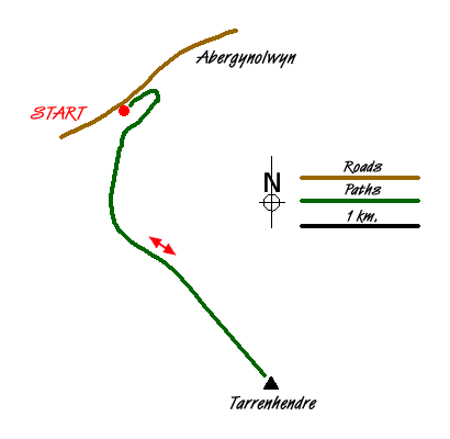
Park in the car park for Abergynolwyn station (grid ref. SH671064). From the car park take the path marked as the railway's link path which runs alongside the railway line initially before cutting beneath the tracks and winding away into the forest. The path is relatively clear and after 10 minutes or so you will find yourself exiting the forest onto a clear gravel track. Take a glance back at where you left the forest as I missed the path on the return route!
Head right up the track and when it hairpins around to the left slightly further on, look for the discrete path leading away into ferns on the right. Take this path which meanders up fairly steeply but clearly through ferns and undergrowth. You will hit a fence on the far right hand side of the forest area before cutting back to the left through a fallen wall and eventually out onto another gravel track. Head right here and after a couple of minutes you'll be greeted by a gate (grid ref. SH669058) beyond which the gravel path becomes grass and often faint, leading away to the right almost counter intuitively.
Stick with this path which eventually bears back around to the left and joins another gate. Go through the gate pass a sheepfold and begin to bear off back to the left still following the faint outline of a path as it rises and cuts through sometimes boggy ground. Around 15 minutes after passing the sheepfold you will come over the crest and see a gate ahead in the distance. Head for this, by the time you reach it, the path ahead will have come very clearly into view.
There are a number of gates to navigate through in what appears to be a sheepfold just short of the main ascent. Once through the gates, a track cuts away from left to right that creates almost a scar on the side of the mountain, ignore this track. Beyond this and directly ahead, a clear path adjacent to the fence that takes you up to the summit is clearly visible, as is its gradient! It is tough going for a short while as the steep ascent heads directly upwards, burning your calves in the process.
Eventually it flattens out and after navigating some boggy ground and a stile, a small cairn marking the summit comes into view. The views around should be good on a clear day including the main Cadair Idris ridge and Tarren Y Gesail nearby, the latter of which can be your next stop if time and conditions allow. Unfortunately neither did for me so I returned back via the outward route in little over an hour from the summit. Allow four hours for the complete walk although for strong walkers it is possible in under three hours.
Messaging & Social Media
Message Walking Britain and follow the latest news.

Mountain Weather
Stay safe on the mountains with detailed weather forecasts - for iOS devices or for Android devices.