Walk 3232 - printer friendly version
Glenridding Dodd & Sheffield Pike Walk
Author - Lou Johnson
Length - 4.5 miles / 7.3 km
Ascent - 1400 feet / 424 metres
Grade - easy/mod
Start - OS grid reference NY386169
Lat 54.5436180 + Long -2.9506035
Postcode CA11 0PD (approx. location only)
Two 'Wainwrights' located to the north-west of Glenridding form the basis of this Lake District circular walk. The first, Glenridding Dodd, was a particular favourite of Victorians venturing into the hills to enjoy the prospect over the southern end of Ullswater and the surrounding hills. The second summit, Sheffield Pike, has less to offer scenically although there are still some views of Lakeland Fells. In periods of poor visibility it should be remembered that Sheffield Pike in particular is flanked to the north and south by extensive steep crags so care should be exercised when navigating this hill.
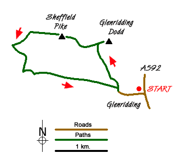
The start is the large pay and display car park in the centre of Glenridding (grid ref. NY386169) on the western side of the main A592 through the village. Exit the car park and follow Greenside Road through the village in a westerly direction. On busy days you will be joining a throng of walkers heading for Helvellyn via Striding Edge. At the end of the village Greenside Road bends right and then left before heading up the valley on the northern side of Glenridding Beck. Where the road bends left, take the footpath on the right to cross a footbridge and start the steep ascent up to the col between Glenridding Dodd and Sheffield Pike where you will reach a gate in a cross wall. Bear right before the wall and continue to the summit of Glenridding Dodd. Do allow time to enjoy the views particularly over Ullswater. In the other direction the panorama includes a number of the higher fells including St Sunday Crag and Helvellyn.
To continue the walk retrace your steps down to the wall to take the onward path up Sheffield Pike's south-east ridge to Heron Pike and an iron post marked on OS maps of the area. The path then trends north for a short way before continuing in a westerly direction to the summit of the fell. The path is generally well walked. There are a couple of areas of boggy ground which can generally be avoided quite easily. The summit is not the most inspiring and the best views are probably enjoyed from Heron Pike.
From the summit walk west and descend to Nick Head (grid ref NY362182) to briefly join the path coming up from Glencoyne and heading across to Stick's Pass. Almost immediately after joining this path take the clear path on your left that descends in a south-westerly direction to join a much wider path coming down from Stick's Pass. Turn left onto this path and descend via a series of zigzags into the valley. Do not cross Glenridding Beck instead use Greenside Road to return to the start.
Messaging & Social Media
Message Walking Britain and follow the latest news.

Mountain Weather
Stay safe on the mountains with detailed weather forecasts - for iOS devices or for Android devices.