Bishop's Stortford to Roydon (Stort Navigation)
Hertfordshire Walk
County/Area - Hertfordshire & Essex
Author - Peter Smyly
Length - 12.0 miles / 19.5 km Ascent - 100 feet / 30 metres
Time - 6 hours 10 minutes Grade - moderate
Walk Route Description
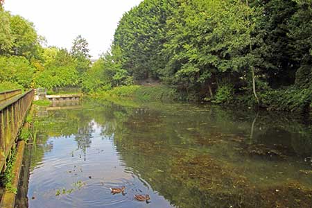
Click image to visit gallery of 8 images.
In a route-finding sense, this walk could hardly be easier as it almost entirely follows the towing path of a canal along part of the Stort Navigation route. A sign near to Spellbrook Lock sums up the route neatly 'Station to station riverside walk'. The distance is around twelve miles between Bishop's Stortford station in Hertfordshire and Roydon station in Essex. Thirteen canal locks are passed en-route. As well as setting, weather and lighting conditions make a difference as to how you perceive places and most of this walk was done on a bright summer's day though it had clouded over by the time Latton Lock was reached. A reminder of the proximity of the route to road and rail occurs from time to time with trains in particular seen or heard or both. Nearby Stansted Airport also means planes flying overhead occasionally. If you decide not to do the whole route, there are railway stations slightly off route at Sawbridgeworth, Harlow Mill and Harlow Town. Alternatively, if you are feeling more energetic, another couple of miles would complete the whole Stort Navigation route by going as far as Feilde's Weir, but this account describes the route as far as Roydon only.
From Bishop's Stortford railway station, cross the car park and walk between residential buildings to locate the canal and bear left along the towing path.
An optional digression of half a mile or so along the canal to the right brings you to the castle mound of Waytemore Castle. There is hardly anything left of the castle itself and climbing the motte is likely to be the only steep uphill section you will do all day.
As to the main walk, my description focuses on the thirteen locks.
Lock 1 South Mill Lock
The first five locks follow 'in initial letter terms' a sequence of S-T-S-T-S. The first one, South Mill Lock, is reached after passing under the railway line and the built-up feel of Bishop's Stortford and the recent crossing of a main road are left behind as in just a few minutes, there is a sense of rural tranquillity. This is one of the prettier locks on the walk with trees either side, a weeping willow being particularly noticeable. Walking south from here, and passing the Bushy Mead Nature Reserve on the left, the scene is visually tranquil with more weeping willows reflected in the water though traffic noise from nearby Hallingbury Road can be heard as the canal follows a meandering course. As a look at the map reveals, the canal and its surrounds are sandwiched between the railway line to the west and a busy road to the east.
Lock 2 Twyford Lock
A lock reached after a quieter, secluded section of the route and a bend in the canal away from Hallingbury Road. A sign next to the road by the lock indicates that Bishops Stortford is one mile from this lock and a wooden seat offers a chance to sit down. The route crosses Pig Lane before entering one of the less populated sections of the route, though the railway line is not far away to the right and passing trains can be heard from time to time if not seen.
Lock 3 Spellbrook Lock
A lock situated in what appears to be a remote stretch of the route, though a look at the map reveals that the hamlet of Spellbrook is just the other side of the railway line to the west while the landmark of Wallbury (an iron-age behemoth) is alongside to the east, though it is not seen from the canal. A carved owl on a tree trunk overlooks the other side of the canal just ahead of the lock. It is not particularly scenic though as a location despite its relatively wild feel. Watch out for occasional cars when crossing Dell Lane next to the lock.
Lock 4 Tednambury Lock
After a significant bend in the canal, and the path accordingly, to the left and a dividing of the waterways, the route continues to the right due south to reveal ahead one of the more scenic locks on this walk, in terms of its setting with an open aspect of fields. This lock is backed by a row of trees and the scene was enhanced by - just a little further on - bulls grazing in a field opposite and a family of swans gracefully gliding by downstream. A sign by the lock reminds you of the proximity of civilisation - a bistro five minutes' walk away across a field at Little Hallingbury Mill. The lock apparently takes its name from nearby Tednambury Farm.
Lock 5 Sawbridgeworth Lock
The route passes under a railway bridge (Kecksy's Bridge) and Sawbridgeworth is 3/4 of a mile from here as a sign indicates while Bishop's Stortford is 3 miles the other way. Despite its proximity to a town, this is another pretty lock, especially the view looking back at it from downstream. Although a row of terraced houses appears on the other side of the canal, the main built-up area comes further along when the next lock comes into view, Sheering Mill Lock. Sawbridgeworth is the first point on the route where you can curtail the walk by taking a train from the nearby station of the same name.
Lock 6 Sheering Mill Lock
This lock appears about a kilometre after passing Sawbridgeworth Lock and just after passing a residential area of apartments on the other side of the canal. The route crosses Sheering Lock Lane, next to the lock, where a nearby sign welcomes you to 'Hertfordshire, the county of opportunity'. Sheering is the name of a village in the Epping Forest part of Essex.
Lock 7 Feakes Lock
A look at the map reveals that Feakes Lock is a kilometre to the east of Pishiobury Park. This is another pretty location with a remote feel about it despite being only about 200 metres from the railway line. There are nearby fields and hedgerows and this is a pleasant and peaceful place to stop on a warm summer's day. The lock is in a quieter stretch of the route between the built-up areas of Sawbridgeworth and Harlow Town.
Lock 8 Harlow Lock
After Feakes Lock, the route follows a meandering course, passing close to the railway line at one point, but much of this stretch has a remote feel about it as it runs in tandem with the canal for the most part. The remote feel changes once Harlow Mill is reached. Harlow Lock is a pretty one, despite its being near to a busy road. A glimpse looking down on it is seen between tree branches from the A1184 road bridge, but the lock itself is scenic with Harlow Mill nearby and a lock keeper's cottage next to the towing path. A sign on a stone by the lock reminds us of life's transient circumstances, declaring 'Man may come and go but the river goes on forever'.
Lock 9 Latton Lock
The Harcamlow Way and Three Forests Way share the same route along here as you come to the next lock. In terms of its location, Latton Lock has the disadvantage of being near to an industrial plant. The route between this lock and the next one involves crossing a footbridge to the other side of the canal from where the railway station at Harlow Town and Burnt Mill Lock are another mile away along a clear track.
Lock 10 Burnt Mill Lock
Burnt Mill Lock is near the site of the former Burnt Mill and is near to both a very busy main road and Harlow Town railway station. You may have decided to call it a day at this point. If not, it is another 2.5-3 miles to Roydon, the next railway station. A full-length view of the lock can be seen from the road bridge with the lock keeper's cottage on the right. The Outdoor Climbing Wall is a conspicuous landmark nearby on the other side of the canal.
Lock 11 Parndon Mill Lock
About half a mile only downstream from Burnt Mill Lock, this one has a semi-rural feel and comes after a quiet rural stretch between the two locks. In season, there may be sloe berries and rose hips growing nearby. In September 2016, three pigs dozed in a nearby field, enjoying the unusually warm sunshine for the time of year. The canal stretch between here and the next lock is visually pleasant though the route keeps company with a busy main road on the other side - the A414 - for part of the route.
Lock 12 Hunsdon Mill Lock
Another lock on the Stort Navigation route named after one of the local mills. Quite a pretty setting with trees alongside and a rural feel about it. Apart from the sound of trickling water, the murmur of distant traffic could be heard and the occasional aeroplane passing overhead. Hunsdon Mead Nature Reserve is next to the lock and offers an alternative continuation route to the canal towing path if heading towards Roydon but the normal approach is the more direct one along the towing path.
Lock 13 Roydon Lock
Quite possibly the easiest of the thirteen locks on this walk to visualise and recall afterwards. A row of moored houseboats alongside the canal announced its imminent appearance when approached from the Hunsdon Mead Nature Reserve direction. A distinctive lock with colourful floral displays and ornaments, a sign saying 'Welcome to Roydon Lock' and, on the other side from the towing path, a tea shop with an outdoor garden seating area with sunflowers. A pleasant place to stop, and despite the tranquil setting, the railway station is just a few minutes' walk further along the canal towing path.
Maps 

| Ordnance Survey Explorer 194 | Sheet Map | 1:25k | BUY |
| Anquet OS Explorer 194 | Digital Map | 1:25k | BUY |
| Ordnance Survey Digital Map Subscription | |||
| Latest Ordnance Survey Discounts | |||
Other walks nearby
| Walk 2110 | Ash Valley Circular | easy | 5.5 miles |
| Walk 2411 | Albury Circular | easy/mod | 7.5 miles |
| Walk 2306 | Furneux Pelham Circular | easy/mod | 7.0 miles |
| Walk 1125 | Widford & Cold Christmas Circular | easy/mod | 9.5 miles |
| Walk 3530 | Roydon to Epping | easy/mod | 9.3 miles |
| Walk 2348 | Bourne Valley & Sacombe from Wadesmill | easy/mod | 5.8 miles |
| Walk 3352 | The Greenwich Meridian, near Ware | easy | 3.3 miles |
| Walk 1725 | St Margaret's circular via Widford | moderate | 10.2 miles |
| Walk 1698 | Ware to Enfield Lock - Lea Valley - | easy/mod | 12.5 miles |
| Walk 1741 | Rye House circular via Roydon and Stanstead Abbots | easy/mod | 9.1 miles |
