Walk 3254 - printer friendly version
Holkham & Holkham Park Circular Walk
Author - Lou Johnson
Length - 10.2 miles / 16.6 km
Ascent - 500 feet / 152 metres
Grade - moderate
Start - OS grid reference TF891448
Lat 52.9672050 + Long 0.8143924
Postcode NR23 1RJ (approx. location only)
This Holkham circular walk in Norfolk is full of interest. One of the highlights of this route are the grounds of Holkham Hall and Park with its splendid landscaping, deer, and other features. The route also features a section of the Norfolk Coast Path through Holkham National Nature Reserve and across the vast sandy beach.
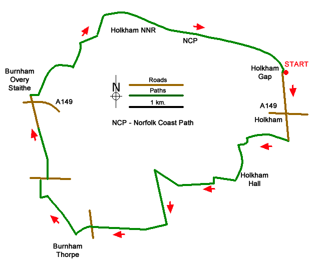
The start is the pay and display car park at Holkham Gap (grid ref. TF891448) which can be easily reached from the A149 coast road between Wells-next-the Sea and Burnham Overy Staithe. After park walk south to the A149. Cross the main road and walk up Park Road which is lines by elegant Estate houses. You soon enter Holkham Park along a tree lined avenue. Continue past a car park on your right and pass through an archway. Take the first gravel path on the right. Continue ahead towards the Coke Monument (grid ref. TF884436).
Turn left just before the monument and then bear right across grass to reach the lake. Turn left along the lake (water on your right) to pass close to Holkham Hall on your left. Reaching the southern end of the lake continue ahead through a gate (signed Walled Garden). Continue through another gate and turn left along a drive. At the next junction turn right and continue to the West Lodge of Holkham Park. Immediately after the house, turn sharp left onto a former Roman road with woods on your left. Continue south for just under a kilometre and turn right along a track leading (with hedge right) to a red-tiled barn. Continue ahead on a concrete track to reach a lane (grid ref. TF856419).
Go straight across the lane to join a track (signed bridleway). The track curves to the left and then right before reaching All Saints Church on your left. A tarmac drive comes in from the left. Turn right here through a small gate in the hedge (left of a pole supporting power cables). The path follows the right-hand hedge before crossing a stile and heading diagonally across a larger field towards trees on the far side. Pass through a gate and turn left following an old railway line for 100 metres. Turn right off the railway track at a waymark to enter a field. Turn right and follow the hedge on your right to reach the B1155 (grid ref. TF846418).
Turn right and after 120 metres turn left onto a clear track with fingerpost (just past the last house on the left). Follow this track (Gong Lane) all the way into Burnham Overy Staithe. Turn left onto the A149 and immediately right into East Harbour Way. Where this road bends left, turn right onto a path (Norfolk Coast Path) that runs in front of a 'black' house. Continue alongside the car park on your left before turning left to continue along the Norfolk Coast Path (grid ref. TF846443).
Initially the path is on an embankment amidst salt marshes. Continue along the clear path through Holkham Nature Reserve to join a boardwalk through sand dunes. At the end of boardwalk bear right and follow a path through dunes to the beach. You have a choice of routes. Either continue along the beach for about three kilometres to reach Holkham Gap or walk through sand dunes or enjoy the shade of a path beneath pine trees. Take care not to overshoot Holkham Gap especially when walking on the beach!
Messaging & Social Media
Message Walking Britain and follow the latest news.

Mountain Weather
Stay safe on the mountains with detailed weather forecasts - for iOS devices or for Android devices.