Walk 3262 - printer friendly version
Copplestone Gate and Conistone Pie from Conistone Walk
Author - Lou Johnson
Length - 7.0 miles / 11.4 km
Ascent - 1300 feet / 394 metres
Grade - easy/mod
Start - OS grid reference SD978675
Lat 54.103383 + Long -2.0351388
Postcode BD23 5HS (approx. location only)
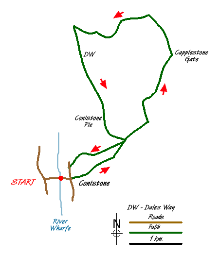
An interesting Yorkshire Dales walk that explores the high ground east of Wharfedale above the village of Conistone. The route includes the Conistone Dib, a limestone gorge, the gritstone ridge by Capplestone Gate and a section of the Dales Way that includes the Conistone Pie.
The start is the small parking areas on either side of the bridge over the Wharfe between the main road at Kilnsey Crag and Conistone village (Grid ref. SD978675). From here walk into the village and keep to the left of the small village green with its maypole. Continue straight ahead on a track with some cottages on your left. This leads into a path passing through a narrow trough to enter a wider section of valley. Quite soon the valley narrows and you enter the rocky confines of Conistone Dib.
Continue to the top of the valley emerging onto a track. Turn left along this and then enter Bycliffe Road (Grid ref. SD992682) using the gate. Turn right along this old packhorse route. The track becomes walled. Where it turns sharp right, bear left through a gate and follow the path, which turns right (northeast) towards a conifer plantation, which is passed on your left. The onward path leads towards the left of a gritstone outcrop and on to the OS trig point at Capplestone Gate (Grid ref. SE001699). Cross the wall and follow the clear path through some old lead mine spoil heaps. Ignore the path crossing (Grid ref. SE001703) and continue straight ahead keeping the wall to your left.
Reaching another path junction (Grid ref. SD997708) cross the wall using the stile and descend the pasture. The path develops into a track. However note that the right of way does not follow this track but assumes a different route to the south. Whichever route you choose, continue to lose height aiming for the southerly corner of a plantation (Grid ref. SD981705) and the Dales Way. Turn sharp left here and follow the Dales Way south across Swineber Scar. The going is easy and progress is fast as you make for the top of Conistone Dib.
Look out for a 'pork pie' shaped limestone outcrop on your right (Grid ref. SD988685) - this is the Conistone Pie! After inspecting this rather interesting shaped outcrop continue south along the Dales Way to reach Bycliffe Road. Rather than descending into the Dib, turn right along the Track into what becomes Scot Gate Lane. This takes you downhill to a tarmac lane. Turn left and you soon reach Conistone and the road leading back to the start.
Messaging & Social Media
Message Walking Britain and follow the latest news.

Mountain Weather
Stay safe on the mountains with detailed weather forecasts - for iOS devices or for Android devices.