Walk 3271 - printer friendly version
Grafham Water Circular Walk
Author - Lou Johnson
Length - 8.7 miles / 14.1 km
Ascent - 300 feet / 91 metres
Grade - easy/mod
Start - OS grid reference TL167680
Lat 52.2977390 + Long -0.2901182
Postcode PE28 0BH (approx. location only)
This circular walk around Grafham Water follows excellent paths and offers views across the reservoir. Built in 1965 the reservoir The reservoir is colonised by wildlife with a nature reserve created on the western side. In season the water is home to many species of birds. In addition, the reservoir is a centre for sailing, fishing, cycling wand walking.
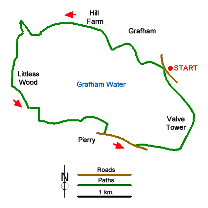
The walk starts from the large Marlow car park adjacent to the Grafham Water Visitor Centre (grid ref. TL167680) which is located about a mile south of Grafham Village. The centre has refreshments and toilets. After parking walk towards the north of the car park and turn right to join a clear path. Nearing Buckden Road, the path turns left through woodland. After 300 metres fork left and follow the path alongside the reservoir. Continue along the waterside path to reach a small parking area by Hill Farm (grid ref. TL148693).
The path soon bears right and passes through Savage's Spinney. Shortly after leaving the trees, you cross a footbridge (grid ref. TL130695). The next section of path continues away from the reservoir shore. You pass through Littless Wood and continue on the clear path to reach Grafham Water car park (grid ref. TL143671). The path passes to the right of the car park with more refreshments available at the Harbour View Café on your left.
You soon pass Grafham Water Sailing Club on your left. At the end of the sailing club premises the path turns sharp right (grid tef. TL151671) and turns south to join Chichester Way. Continue ahead to a reach a T-junction with the Wheatsheaf pub opposite. Turn left along the B661 and continue for 400 metres (grids ref. TL 154668) where you turn left onto the signed path which runs parallel to the road through trees. Continue through Plummer Park passing the car park on your right. Soon after the path bears right across the reservoir dam and takes you back to the car park used at the start of walk.
Messaging & Social Media
Message Walking Britain and follow the latest news.

Mountain Weather
Stay safe on the mountains with detailed weather forecasts - for iOS devices or for Android devices.