Walk 3272 - printer friendly version
Conival & Ben More Assynt from Inchnadamph Walk
Author - Lou Johnson
Length - 11.0 miles / 17.9 km
Ascent - 3940 feet / 1194 metres
Grade - hard
Start - OS grid reference NC251216
Lat 58.1485800 + Long -4.9734388
Postcode IV27 4HN (approx. location only)
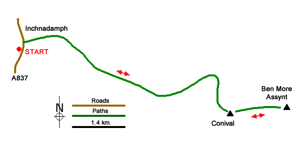
This walk from Inchnadamph includes the Munros of Conival and Ben More Assynt. The route initially follows the River Traligill past the Traligill Caves before turning north-east for a steep ascent onto the north ridge of Conival. The route turns south to Conival's summit before heading east to Ben More Assynt. Paths are mainly good but are intermittent in places on the higher ground.
The start is the Rock Trail car park (grid ref. NC251216) on the east side of the A837 at Inchnadamph. After parking exit the car park and turn right along the A837. Cross the river bridge and turn right onto a track signed to Traligill Caves. Follow the good track for 1.6 kilometres to reach Glenbain Cottage. Continue ahead, with the cottage on your left, onto a grassy path which soon leads through an enclosed field to pass a small plantation on your left (grid ref. NC269212). 150 metres beyond the trees you reach a path junction where you take the left fork (the right fork leads over a footbridge and up to the Traligill Caves).
The path continues up Gleann Dubh with the River Traligill on your right. About two kilometres from the plantation the path bears left and starts to climb with the Allt a' Choinne' Mhill on your right. The way ahead steepens and the route trends south as you gain Conival's north ridge. A path climbs through a rocky landscape to reach the summit with its wind shelter and spectacular 360-degree panorama.
From Conival the onward route to Ben More Assynt is clear. The route heads east with a path descending rocky ground towards a col. From here a final ascent over similar ground leads to Ben More Assynt with the highest point at the eastern end of the rocky summit. Again, the view is outstanding although my preference is the one from Conival. The return route follows the outward route back to Inchnadamph.
Messaging & Social Media
Message Walking Britain and follow the latest news.

Mountain Weather
Stay safe on the mountains with detailed weather forecasts - for iOS devices or for Android devices.