Conival & Ben More Assynt from Inchnadamph
Highland Walk
County/Area - Highland - Northern Highland
Author - Lou Johnson
Length - 11.0 miles / 17.9 km Ascent - 3940 feet / 1194 metres
Time - 9 hours 30 minutes Grade - hard
Walk Route Description
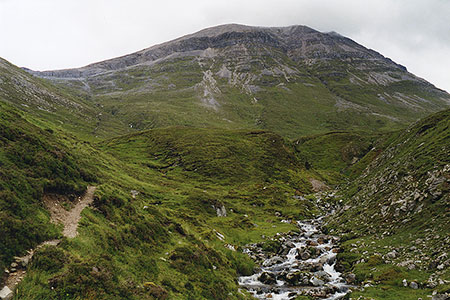
Click image to see photo description.
This walk from Inchnadamph includes the Munros of Conival and Ben More Assynt. The route initially follows the River Traligill past the Traligill Caves before turning north-east for a steep ascent onto the north ridge of Conival. The route turns south to Conival's summit before heading east to Ben More Assynt. Paths are mainly good but are intermittent in places on the higher ground.
The start is the Rock Trail car park (grid ref. NC251216) on the east side of the A837 at Inchnadamph. After parking exit the car park and turn right along the A837. Cross the river bridge and turn right onto a track signed to Traligill Caves. Follow the good track for 1.6 kilometres to reach Glenbain Cottage. Continue ahead, with the cottage on your left, onto a grassy path which soon leads through an enclosed field to pass a small plantation on your left (grid ref. NC269212). 150 metres beyond the trees you reach a path junction where you take the left fork (the right fork leads over a footbridge and up to the Traligill Caves).
The path continues up Gleann Dubh with the River Traligill on your right. About two kilometres from the plantation the path bears left and starts to climb with the Allt a' Choinne' Mhill on your right. The way ahead steepens and the route trends south as you gain Conival's north ridge. A path climbs through a rocky landscape to reach the summit with its wind shelter and spectacular 360-degree panorama.
From Conival the onward route to Ben More Assynt is clear. The route heads east with a path descending rocky ground towards a col. From here a final ascent over similar ground leads to Ben More Assynt with the highest point at the eastern end of the rocky summit. Again, the view is outstanding although my preference is the one from Conival. The return route follows the outward route back to Inchnadamph.
Maps 

| Ordnance Survey Explorer 442 | Sheet Map | 1:25k | BUY |
| Anquet OS Explorer 442 | Digital Map | 1:25k | BUY |
| Ordnance Survey Digital Map Subscription | |||
| Latest Ordnance Survey Discounts | |||
Other walks nearby
| Walk 1319 | The Bone Caves of Inchnadamph | easy | 3.0 miles |
| Walk 1317 | Sail Gharbh (Quinag) | moderate | 5.4 miles |
| Walk 1117 | Glas Bheinn & Eas a' Chual Aluinn (waterfall) | mod/hard | 8.5 miles |
| Walk 2274 | Cul Mor from Knockan Crag | mod/hard | 8.5 miles |
| Walk 1769 | Suilven (North-western approach) | hard | 12.0 miles |
| Walk 1316 | Falls of Kirkaig | easy | 5.8 miles |
| Walk 2529 | Stac Pollaidh Circular | easy/mod | 2.8 miles |
| Walk 1017 | Stac Pollaidh | easy/mod | 3.0 miles |
| Walk 1312 | Achmelvich Bay and Alltanabradhan | easy | 3.0 miles |
| Walk 1266 | The Old Man of Stoer and the Point of Stoer | easy | 4.5 miles |
Recommended Books & eBooks
Great Mountain Days in Scotland
 Inspirational guidebook to 50 challenging routes for mountaineers, scramblers, hillwalkers and fell runners, many long enough to backpack over 2 days, especially in winter (12 to 25 miles). A mix of classic routes and unsung gems across Scotland from Galloway to the Outer Hebrides in widely differing wild landscapes. With customised OS mapping.
More information
Skye's Cuillin Ridge Traverse
 This 2-volume set provides all the information required to complete the main ridge traverse on Skye's Black Cuillin. Strategy, gear, training, navigation and logistics are covered, and 10 classic scrambles are described. A lightweight second guidebook gives the scrambler detailed maps, topos and route description for the ridge traverse itself.
More information
