Walk 3273 - printer friendly version
Ben Starav Walk
Author - Lou Johnson
Length - 8.0 miles / 13 km
Ascent - 3600 feet / 1091 metres
Grade - hard
Start - OS grid reference NN136468
Lat 56.5760040 + Long -5.0360755
Postcode PH49 4JA (approx. location only)
This demanding walk ascends mighty Ben Starav (1078 m.) which lies at the lower end of Glen Etive. The route is an almost continuous climb of over 3,500 feet to reach the summit of this Munro which offers commanding views across the surrounding lochs, glens, and mountains. The terrain is rocky with the walk crossing some narrow rocky ridges. Due to its location, Ben Starav encounters rapid changes in the weather. In winter, the hill should be avoided by those not experienced and equipped for such an outing.
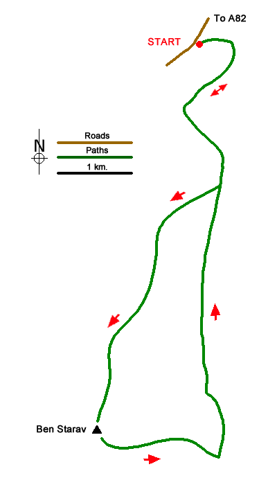
The start is off-road parking in Glen Etive (grid ref. NN136468). On busy days you may need to park elsewhere. Take the private track leading to Coileitir. Pass this cottage on your left and continue parallel to the river on your right. Turn inland to a footbridge (grid ref. NN136460) and turn left beside Allt Mheuran. The path starts climbing and swings south with the river below on your left. You soon reach a path junction (grid ref. NN139453) where you take the right-hand path.
The path climbs onto Ben Starav's north ridge. The well-defined route keeps to the crest of the ridge between Coire Sgroidain on your right and Coire an Fhir Leith to your left. As you make progress up the hill there are dramatic crags on your right with the ridge narrowing. After a sustained ascent over rocky terrain, you reach the trig point on Ben Starav. The views are superb especially to the south over Loch Etive. In addition, the panorama includes Bidean nam Bian, Ben Cruachan and many other peaks.
To start the descent head south-east along the top of the crags falling away to your left. The path continues across the north flank of Stob Coire Dheirg. Care is needed in poor visibility with steep crags to your left. Continue the descent towards Glas Bheinn Mhor to reach a bealach (grid ref. NN139424).
Turn left here and follow the path as it descends, steeply at first, into Coire Lochain Ghaineamhaich. A short way down you pass the tiny Lochan Ghaineamhaich which is just off the path to your right where fresh water is on hand should you need to replenish your supply. Continue down the clear path losing height steadily with a stream below on your right. Continue down the glen to re-join your outward route back to the start.
Messaging & Social Media
Message Walking Britain and follow the latest news.

Mountain Weather
Stay safe on the mountains with detailed weather forecasts - for iOS devices or for Android devices.