Ben Starav from Glen Etive
Highland Walk
County/Area - Highland - Fort William Lochaber
Author - Lou Johnson
Length - 8.0 miles / 13 km Ascent - 3600 feet / 1091 metres
Time - 7 hours 40 minutes Grade - hard
Walk Route Description
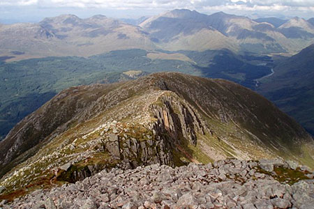
Click image to see photo description.
This demanding walk ascends mighty Ben Starav (1078 m.) which lies at the lower end of Glen Etive. The route is an almost continuous climb of over 3,500 feet to reach the summit of this Munro which offers commanding views across the surrounding lochs, glens, and mountains. The terrain is rocky with the walk crossing some narrow rocky ridges. Due to its location, Ben Starav encounters rapid changes in the weather. In winter, the hill should be avoided by those not experienced and equipped for such an outing.
The start is off-road parking in Glen Etive (grid ref. NN136468). On busy days you may need to park elsewhere. Take the private track leading to Coileitir. Pass this cottage on your left and continue parallel to the river on your right. Turn inland to a footbridge (grid ref. NN136460) and turn left beside Allt Mheuran. The path starts climbing and swings south with the river below on your left. You soon reach a path junction (grid ref. NN139453) where you take the right-hand path.
The path climbs onto Ben Starav's north ridge. The well-defined route keeps to the crest of the ridge between Coire Sgroidain on your right and Coire an Fhir Leith to your left. As you make progress up the hill there are dramatic crags on your right with the ridge narrowing. After a sustained ascent over rocky terrain, you reach the trig point on Ben Starav. The views are superb especially to the south over Loch Etive. In addition, the panorama includes Bidean nam Bian, Ben Cruachan and many other peaks.
To start the descent head south-east along the top of the crags falling away to your left. The path continues across the north flank of Stob Coire Dheirg. Care is needed in poor visibility with steep crags to your left. Continue the descent towards Glas Bheinn Mhor to reach a bealach (grid ref. NN139424).
Turn left here and follow the path as it descends, steeply at first, into Coire Lochain Ghaineamhaich. A short way down you pass the tiny Lochan Ghaineamhaich which is just off the path to your right where fresh water is on hand should you need to replenish your supply. Continue down the clear path losing height steadily with a stream below on your right. Continue down the glen to re-join your outward route back to the start.
Maps 

| Ordnance Survey Explorer 377 | Sheet Map | 1:25k | BUY |
| Anquet OS Explorer 377 | Digital Map | 1:25k | BUY |
| Ordnance Survey Explorer 384 | Sheet Map | 1:25k | BUY |
| Anquet OS Explorer 384 | Digital Map | 1:25k | BUY |
| Ordnance Survey Digital Map Subscription | |||
| Latest Ordnance Survey Discounts | |||
Other walks nearby
| Walk 3118 | Sgor na h'Ulaidh from Achnachon, Glen Coe | mod/hard | 8.0 miles |
| Walk 2955 | Ridges & peaks of Bidean Nam Bian | very hard | 10.5 miles |
| Walk 2554 | The Lost Valley, Glen Coe | easy/mod | 4.2 miles |
| Walk 3251 | Bidean nam Bian via Stob Coire nan Lochan, Glencoe | hard | 5.0 miles |
| Walk 2808 | Buachaille Etive Beag, Glen Coe | hard | 9.0 miles |
| Walk 1162 | Pap of Glencoe | moderate | 4.2 miles |
| Walk 1234 | Pap of Glencoe (Route B) | moderate | 4.2 miles |
| Walk 3000 | Sgorr Nam Fiannaidh & Stob Coire Leith | hard | 6.2 miles |
| Walk 3322 | Sgurr na Ciche (Pap of Glencoe) | moderate | 4.2 miles |
| Walk 2819 | Stob na Broige, Buchaille Etive Mor, Glen Coe | mod/hard | 6.1 miles |
Recommended Books & eBooks
Walking the Munros Vol 2 - Northern Highlands and the Cairngorms
 Guidebook to walking the northern Munros, covering the northern Highlands, the Cairngorms and the Isle of Skye. 70 routes are described, including those up Ben Macdui, Braeriach and Cairn Gorm. Routes range from 7 to 46km, requiring a fair level of fitness. The second of two guidebooks to walking Scotland's Munros: peaks higher than 3000ft.
More information
Skye's Cuillin Ridge Traverse
 This 2-volume set provides all the information required to complete the main ridge traverse on Skye's Black Cuillin. Strategy, gear, training, navigation and logistics are covered, and 10 classic scrambles are described. A lightweight second guidebook gives the scrambler detailed maps, topos and route description for the ridge traverse itself.
More information
