Walk 3291 - printer friendly version
West Kip, East Kip & Scald Law Walk
Author - Lou Johnson
Length - 9.7 miles / 15.8 km
Ascent - 1800 feet / 545 metres
Grade - moderate
Start - OS grid reference NT182655
Lat 55.8756880 + Long -3.3089569
Postcode EH14 7AS (approx. location only)
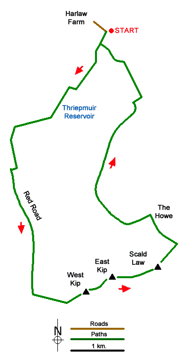
This Pentland Hills walk includes the summits of West and East Kip, and Scald Law. The route follows good paths with no navigational problems. The walk also includes sections beside Harlaw and Thriepmuir Reservoirs, waterfalls in Green Cleugh and some splendid views.
The start is Harlaw car park (grid ref. NT182655) which lies to the south-east of Balerno. After parking, follow the track south-west beside the plantation to the Harlaw House Visitor Centre. Pass the building and turn left along the northern shore of Harlaw Reservoir. Continue to the end of the reservoir and Thriepmuir Reservoir dam. Turn right and follow the clear track with the reservoir on your left. Where the track veers right, continue ahead on a path through Redford Wood to reach a road (grid ref. NT165637).
Turn left and continue south along a tree-lined avenue to a T-junction. Turn right and after 50 metres turn left over a stile into a field. A clear grassy track (Red Road) leads you over a stile and across moorland to reach the ridge (grid ref. NT174604). Turn left (east) and climb to the summit of West Kip. Continue steeply down to a col and head up to the summit of East Kip. Descend to the next col and follow the rising path along the north side of ridge to gain the summit of Scald Law, the highest hill in the Pentland Hills. A trig column marks the summit, and you should allow time to enjoy the extensive view.
Descend north-east to the bealach below Carnethy Hill (grid ref. NT195615). Cross the fence and head north-west down a track The Old Kirk Road). Continue down to The Howe at the eastern end of Loganlea Reservoir. Turn left (upstream) passing a waterfall and through Green Cleugh. Just before reaching a stile (grid ref. NT179625), bear right on a rising path. The path soon starts to descend beside a wall with Black Hill rising on your right.
Reaching a stone hut (grid ref. NT187641) cross Thriepmuir Reservoir and turn right on the other side. Continue for 100 metres and turn left over a stile. The path passes through trees crossing several stiles along the way. Continue ahead to Harlaw Reservoir and follow the path back to the visitor centre and turn along the track back to the car park.
Messaging & Social Media
Message Walking Britain and follow the latest news.

Mountain Weather
Stay safe on the mountains with detailed weather forecasts - for iOS devices or for Android devices.