West Kip, East Kip & Scald Law
Midlothian Walk
County/Area - Midlothian
Author - Lou Johnson
Length - 9.7 miles / 15.8 km Ascent - 1800 feet / 545 metres
Time - 6 hours 40 minutes Grade - moderate
Walk Route Description
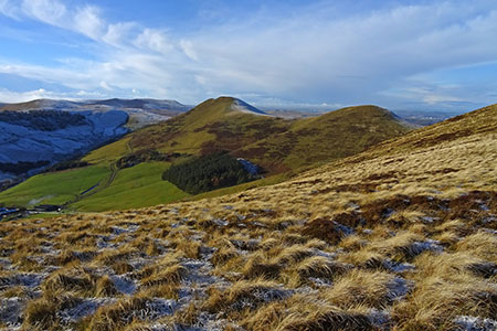
Click image to see photo description.
This Pentland Hills walk includes the summits of West and East Kip, and Scald Law. The route follows good paths with no navigational problems. The walk also includes sections beside Harlaw and Thriepmuir Reservoirs, waterfalls in Green Cleugh and some splendid views.
The start is Harlaw car park (grid ref. NT182655) which lies to the south-east of Balerno. After parking, follow the track south-west beside the plantation to the Harlaw House Visitor Centre. Pass the building and turn left along the northern shore of Harlaw Reservoir. Continue to the end of the reservoir and Thriepmuir Reservoir dam. Turn right and follow the clear track with the reservoir on your left. Where the track veers right, continue ahead on a path through Redford Wood to reach a road (grid ref. NT165637).
Turn left and continue south along a tree-lined avenue to a T-junction. Turn right and after 50 metres turn left over a stile into a field. A clear grassy track (Red Road) leads you over a stile and across moorland to reach the ridge (grid ref. NT174604). Turn left (east) and climb to the summit of West Kip. Continue steeply down to a col and head up to the summit of East Kip. Descend to the next col and follow the rising path along the north side of ridge to gain the summit of Scald Law, the highest hill in the Pentland Hills. A trig column marks the summit, and you should allow time to enjoy the extensive view.
Descend north-east to the bealach below Carnethy Hill (grid ref. NT195615). Cross the fence and head north-west down a track The Old Kirk Road). Continue down to The Howe at the eastern end of Loganlea Reservoir. Turn left (upstream) passing a waterfall and through Green Cleugh. Just before reaching a stile (grid ref. NT179625), bear right on a rising path. The path soon starts to descend beside a wall with Black Hill rising on your right.
Reaching a stone hut (grid ref. NT187641) cross Thriepmuir Reservoir and turn right on the other side. Continue for 100 metres and turn left over a stile. The path passes through trees crossing several stiles along the way. Continue ahead to Harlaw Reservoir and follow the path back to the visitor centre and turn along the track back to the car park.
Maps 

| Ordnance Survey Explorer 344 | Sheet Map | 1:25k | BUY |
| Anquet OS Explorer 344 | Digital Map | 1:25k | BUY |
| Ordnance Survey Digital Map Subscription | |||
| Latest Ordnance Survey Discounts | |||
Other walks nearby
| Walk 1936 | Scald Law and Pentland Hills Ridge from near Penicuik | mod/hard | 7.4 miles |
| Walk 3292 | Carnethy Hill, Black Hill & Caerketton Hill | mod/hard | 12.5 miles |
| Walk 1700 | Edinburgh - Royal Mile, Arthur's Seat & Princes Street | easy | 5.5 miles |
| Walk 1803 | Edinburgh - Salisbury Crags and the Royal Mile | easy | 4.0 miles |
| Walk 2061 | Edinburgh - Calton Hill and the city centre | easy | 3.0 miles |
| Walk 2241 | Gladhouse Reservoir | easy | 4.0 miles |
| Walk 1979 | Culross Heritage | easy | 1.5 miles |
| Walk 3294 | Trahenna Hill from Broughton | moderate | 7.1 miles |
| Walk 1557 | The Falkirk Wheel and the Kelpies | easy/mod | 8.0 miles |
| Walk 3751 | Tinto (northern approach) | moderate | 4.5 miles |
