Walk 3294 - printer friendly version
Trahenna Hill from Broughton Walk
Author - Lou Johnson
Length - 7.1 miles / 11.5 km
Ascent - 1500 feet / 455 metres
Grade - moderate
Start - OS grid reference NT112365
Lat 55.6139610 + Long -3.4113616
Postcode ML12 6HG (approx. location only)
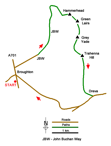
A walk from Broughton (Scottish Borders) that takes you onto a fine ridge running north from Trahenna Hill (549 m.). The route crosses the eastern flank of Clover Law following a section of the John Buchan Way. Reaching a broad col, the walk turns south across Hammer Head, Green Lairs, ands Grey Yade to arrive on the summit of Trahenna Hill. Excellent views can be enjoyed along the route especially into the Upper Tweed valley. The walk mostly follows good paths and tracks.
The start is Broughton which lies on the A701 north of Moffat. On street parking is available in the village (grid ref. NT112365) although please park with consideration. After parking walk north through the village and take the first lane on the right over a small stone bridge signed to Broughton Place with a fingerpost on the left side of the main road. Follow the lane (John Buchan Way) through a pleasant avenue of trees passing a farm and Broughton Place along the way to reach a small car park by a cottage (grid ref. NT120375).
Go through the gate and follow the rising track across the east flank of Clover Law to arrive at a broad col between Broomy Side and Hammer Head (grid ref. NT127392). Turn right and follow the fence to the summit of Hammer Head (513 m.), which is the start of an undulating ridge that terminates at Trahenna Hill. Continue by the fence over Green Lairs and Grey Yade. A final climb leads to the summit of Trahenna Hill which is on the south side of a wall (grid ref. NT136674).
Descend due south from Trahenna Hill along the south ridge for about a kilometre. Then head half left (southeast) down towards the farm buildings at Dreva (grid ref. NT140359). Turn right along the road and where the road forks, bear right, and follow the upper road back to Broughton.
Messaging & Social Media
Message Walking Britain and follow the latest news.

Mountain Weather
Stay safe on the mountains with detailed weather forecasts - for iOS devices or for Android devices.