Walk 3299 - printer friendly version
Loch an Eilein from Coylumbridge Walk
Author - Andy Smith
Length - 7.0 miles / 11.4 km
Ascent - 550 feet / 167 metres
Grade - easy/mod
Start - OS grid reference NH915107
Lat 57.174257 + Long -3.796171
Postcode PH22 1QG (approx. location only)
The Cairngorm National Park is renowned for its huge 4,000 foot summits, some of the highest in the UK and is a magnet for outdoor pursuits. However there are some stunning forest walks that are overlooked as people head for the hills.
This route shares its starting point with walk 1721 where a superb campsite is located. For those not using the campsite, parking can be found in two lay-bys on the ski centre access road from Aviemore. As in most walks in the Cairngorms this one is at its best in winter conditions although it can also be enjoyed in the summer months by all the family.
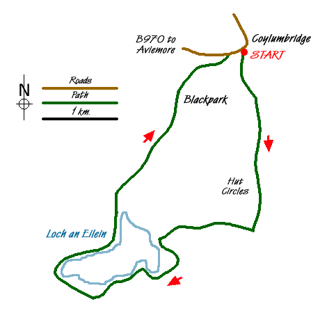
After parking, walk through the campsite bearing right on the raised bank. Within minutes you find yourself on the Larig Ghru Footpath. After 500m the path splits (grid ref. NH917100). Bear right signed Glen Einich and follow the path. The path gently rises and after a while you take in the scale of the huge Rothiemurchus Forest, one of the largest in the UK. The way ahead is clear as you pass signs for Balvattan hut circles which are well worth a quick look if time is on your side. Continue on until the first major junction is reached (grid ref. NH916079). Turn right signed Loch an Eilein.
The path heads slightly downhill and crosses through some new plantations. After half an hour the path reaches a T junction. Turn left here ignoring the sign to Aviemore. You are now on the Loch an Eilein circular route. In winter months the first sight of Loch an Eilein is totally amazing with the frozen landscape and crystal still waters. Continue round the loch crossing the outlet river via a small footbridge (grid ref. NH 893072) as you head round to Loch an Eilein Cottage.
After a quality hour spent walking round the loch, the second outlet is reached. Stay close to the waters edge and cross the footbridge. Within minutes the main Aviemore track is reached once again. Turn left here and press on to the car park access road (grid ref. NH897086). Almost immediately an estate access track appears to your right. Take this and head into the clearing towards the Croft remains. After 1.5km a small sealed road appears at Blackpark. Continue along for 50m and take the footpath to the right signed Rothiemurchus track. This will take you directly back to Coylumbridge.
Once near the road you have a two way decision, continue along where the track terminates next to the campsite entrance from where you started, or bear right at grid ref. NH915106 for a well earned drink in the Hilton public bar!
Messaging & Social Media
Message Walking Britain and follow the latest news.

Mountain Weather
Stay safe on the mountains with detailed weather forecasts - for iOS devices or for Android devices.