Walk 3309 - printer friendly version
Hartsop, Hartsop Dodd, Stony Cove Pike & Kirkstone Pass Walk
Author - Lou Johnson
Length - 8.5 miles / 13.8 km
Ascent - 2400 feet / 727 metres
Grade - moderate
Start - OS grid reference NY410130
Lat 54.508859 + Long -2.9127286
Postcode CA11 0NY (approx. location only)
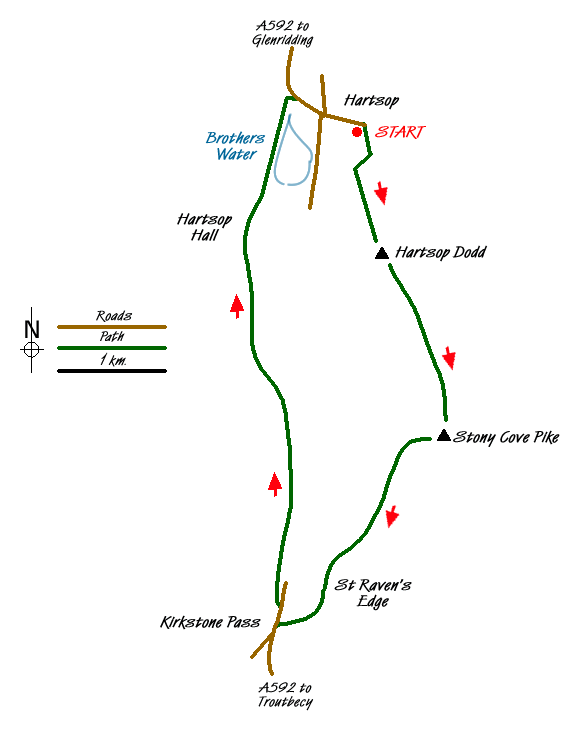
This Lake District hike includes two Wainwrights and a famous Lakeland Pass so is never short of interest. The first part of the walk involves a steep ascent but this is not as bad as it looks. Once the summit of Hartsop Dodd is reached the going is relatively easy and straightforward. There is limited parking at the end of the lane through Hartsop village (Grid ref. NY409130) and at busy times this is full. Do remember to leave a donation as this car park is provided as a service to walkers. An alternative would be the car park at Cow Bridge (grid ref. NYNY403134).
From the car park you can see Hartsop Dodd and the path going up its steep slopes. Follow the track up the valley turning right to cross the river. Almost immediately across the bridge leave the track and follow the path uphill with the wall on your right. You soon cross the intake wall onto the open fellside and the path begins to zigzag making the going much easier. Frequent stops can be justified to admire the scenery!
Reaching the small cairn on Hartsop Dodd has seen the back of most of the ascent and you can now look forward to stepping out across the fells. The onward path follows the ridge wall to Stony Cove Pike, the second Wainwright of the walk. The summit is not very inspiring and you can improve the views by walking east to overlook Threshwaite Mouth and Thornthwaite Beacon.
Leave the summit by taking the main path west and then south. Again you are following a wall and even in mist it is hard to go astray on this section as you gently lose height towards Kirkstone Pass. The immediate surroundings are not too exciting on this descent. However reaching St Raven's Edge, some more ascent is required, which is compensated by a more interesting path and some mild scrambling as you make the descent to the main road and pub at Kirkstone Pass.
To continue, cross the road into the car park opposite the pub and walk north. There is a path (not shown on OS maps) that starts at the northern end of the car park and leads down to a marked concessionary path that is marked on OS maps at grid ref. NY403092. The route is easy to follow and generally keeps to the west of the stream. There was some wet ground the day I walked this section but it was generally avoidable and far preferable to walking down the main road! Reaching a junction of paths (grid ref. NY399107) the route of the path was hard to pick up on the ground. However this problem was soon solved using the map and the main path down to Hartsop Hall was easily followed.
From Hartsop Hall - a beautiful Lakeland farm - continue north on the clearly waymarked path to reach the western shores of Brothers Water. At the northern end of the lake bear right and turn right along the main road. At the first junction take the minor road on the left and follow the lane through the village back to the parking area.
Messaging & Social Media
Message Walking Britain and follow the latest news.

Mountain Weather
Stay safe on the mountains with detailed weather forecasts - for iOS devices or for Android devices.